1-1. The Manual of Surveying Instructions describes how cadastral surveys of the public lands are made in conformance to statutory law and its judicial interpretation. This chapter summarizes the various Acts and the general plans of surveying based on them. Previous editions of the Manual were issued in 1855 (reprinted as the Manual of 1871), 1881, 1890, 1894, 1902, 1930, and 1947.
1-2. Surveying, in general, is the art of measuring and locating lines, angles, and elevations on the surface of the earth, within underground workings, and on the beds of bodies of water. A "cadastral survey" creates (or reestablishes), marks, and defines boundaries of tracts of land. In the general plan this includes a field-note record of the observations, measurements, and monuments descriptive of the work performed and a plat that represents the cadastral survey, all subject to approval of the Director, Bureau of Land Management.
1-3. Details of the plan and its methods go beyond the scope of textbooks on surveying. The application to large-scale areas requires an understanding of the stellar and solar methods for making observations to determine the true meridian, the treatment of the convergency of meridians, the running of the true parallels of latitude, and the conversion in the direction of lines so that at any point the angular value will be referred to the true north at that place. These subjects are therefore explained and examples given with specific relation to the approved surveying practice. The use, care and adjustments of the solar transit are fully treated because of its wide use in public land surveying. The applications of photogrammetry and electronic instrumentation to public land surveying are covered for the first time in the addition of the Manual.
1-4. Extended treatment is given to subdivision of sections, restoration of lost or obliterated corners, resurveys, and special surveys of many kinds. These now make up the major part of the surveying program of the Bureau of Land Management. Stress is placed on thoroughness in the identification and perpetuation of the surveys already completed.
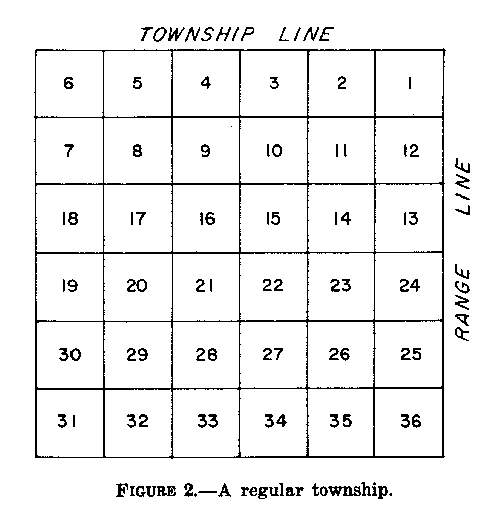
1-5. The surveys of public lands have been conducted since 1785, when a beginning point was established where the west boundary of Pennsylvania crosses the north bank of the Ohio River. The first surveys, covering parts of Ohio, were made under supervision of the Geographer of the United States in compliance with the Ordinance of May 20, 1785. Detailed instructions were not needed in these initial surveys, because only the exterior lines of the townships were surveyed, and only mile corners were established. Township plats were marked by subdivisions into sections or "lots" one mile square, numbered from 1 to 36, commencing with No. 1 in the southeast corner of the township and running from south to north in each sequence to No. 36 in the northwest corner of the township.
1-6. The Act of May 18, 1796, provided for the appointment of a Surveyor General, whose duty was to survey the public lands northwest of the Ohio River. Half of the townships were to be subdivided into two-mile blocks, and the rule for numbering of sections within the township was changed to that practiced today. Subsequent laws called for additional subdivision, and the system of surveys was gradually refined to its present form. In the early period advice and general instructions were given the Surveyor General by the Secretary of the Treasury, then in charge of land sales, and later by the Commissioner of the General Land Office. Instructions to deputy surveyors were issued by the Surveyor General. A Surveyor of the Lands of the United States South of Tennessee was appointed in 1803 with the same duties as the Surveyor General, and eventually a surveyor general was appointed for each of many public-land States and Territories.
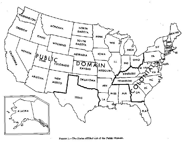
Figure 1. - The States created out of the Public Domain (See page 2 of the Manual)
1-7. In 1831 the Commissioner of the General Land Office issued detailed instructions to the surveyors general concerning surveys and plats. The applicable parts were incorporated by individual surveyors general in bound volumes of instructions suitable for use in the field by deputy surveyors. From these directions evolved the Manual of Surveying Instructions. The Act of July 4, 1836, placed the overall direction of the public land surveys under the principal clerk of surveys in the General Land Office. The immediate forerunner of the Manual series was printed in 1851 as "Instructions to the Surveyor General of Oregon; Being a Manual for Field Operations." Its use was at once extended to California, Minnesota, Kansas, Nebraska, and New Mexico. In a slightly revised version these instructions were issued as the Manual of 1855.
1-8. The following supplements to this Manual are for sale by the Superintendent of Documents, U.S. Government Printing Office, Washington, D.C., 20402:
(1) Standard Field Tables and Trigonometric Formulas. Semi- hard cover, pocket-size, 4� x 7, 245 pages. First published by the General Land Office in 1910, eighth edition published in 1956. The tables and data are designed for use by cadastral surveyors in the field and office.
(2) The Ephemeris of the Sun, Polaris and Other Selected Stars with Companion Data and Tables. Paper cover, 6 x 9, 30 pages and a star chart. Published annually in advance since 1910. Data for the sun are given in terms of Greenwich apparent noon for ready use with the solar transit. Data for all stellar positions are given in terms of the Greenwich meridian, mean time and mean time intervals. The data are prepared by the Nautical Almanac Office of the United States Naval Observatory.
(3) Restoration of Lost or Obliterated Corners and Subdivision of Sections, a Guide for Surveyors. Paper cover, 6 x 9, 40 pages, illus. The subject matter under this title first appeared in the decisions of the Department of the Interior, 1 L.D. 339; 2d ed., 1 L.D. 671 (1883). There have been several revisions and extensions, the latest in 1972. Providing an introduction to the rectangular system of public land surveying and resurveying, with a compendium of basic laws relating to the system, it answers many common questions arising in practical work. Although intended especially for surveyors outside the Bureau of Land Management, it is also of interest to attorneys, title insurance company personnel, and others who have professional interests in former or present public lands.
1-9. The original public domain included the lands that were turned over to the Federal Government by the Colonial States and the areas acquired later from the native Indians or foreign powers. Insofar as public land surveys are concerned, "public lands" are those which, after inuring to the United States, have remained in public ownership, or, after private acquisition, have been returned to public ownership and the status of public land by law.
1-10. After admission of the States into the Union, the Federal Government has continued to hold title to and administer the unappropriated lands. Various enabling acts expressly provide that the title to unappropriated lands within these States shall be retained by the United States. Moreover, lands in the territories not appropriated by competent authority before they were acquired are in the first instance the exclusive property of the United States, to be administered, or for disposal to such persons, at such time, in such modes, and by such titles as the Government may deem most advantageous to the public. Congress alone has the power, derived from Article IV, Section 3, of the Constitution, of disposing of the public domain and making all needful rules and regulations in respect thereto.
1-11. It is within the province of the Director of the Bureau of Land Management to determine what are public lands, what lands have been surveyed, what are to be surveyed, what have been disposed of, what remains to be disposed of, and what are reserved. By a well settled principle of law the United States, through the Department of the Interior, has the authority and duty to extend the surveys as may be necessary to include lands erroneously omitted from earlier surveys.
1-12. Beds of navigable bodies of water are not public domain and are not subject to survey and disposal by the United States. Sovereignty is in the individual states. Under the laws of the United States the navigable waters have always been and shall forever remain common highways. This includes all tidewater streams and other important permanent bodies of water whose natural and normal condition at the date of the admission of a State into the Union was such as to classify it as navigable water. Tidelands which are covered by the normal daily overflow are not subject to survey as public land. (See discussion in chapter VII on Special Surveys.)
1-13. In Alabama, California, Florida, Illinois, Indiana, Iowa, Louisiana, Michigan, Minnesota, Mississippi, Ohio, Oregon, and Wisconsin, the swamp and overflowed lands, through public domain, pass to the States upon identification by public land survey, and approved selection, the title being subject to the disposal by the States.
1-14. The Act of March 2, 1849 (9 Stat. 352), granted to the State of Louisiana all its swamp and overflowed lands for the purpose of aiding in their reclamation. The Act of September 28, 1850 (9 Stat. 519), extended the grant to other public land States then in the Union. The grant was also extended to Minnesota and Oregon by the Act of March 12, 1860 (12 Stat. 3). These various grants were carried over into R.S. 2479 (43 U.S.C. 982). A notable exception to the swamp land laws is found in the Arkansas Compromise Act of April 29, 1898 (30 Stat. 367; 43 U.S.C. 991), by which all right, title, and interest to the remaining unappropriated swamp and overflowed lands reverted to the United States.
1-15. The provisions of the grants apply to elevations below the uplands where, without the construction of levees or drainage canals, the areas would be unfit for agriculture. The grants apply to all swamp and overflowed lands unappropriated at the dates of the granting acts, whose character at that time would bring them within the provisions of the grant. Discussion of swamp and overflowed lands in connection with field examinations and surveys is found in chapter VII on Special Surveys.
1-16. Principal early laws are found in:
(1) "An ordinance for ascertaining the mode of locating and disposing of lands in the western territory, and for other purposes therein mentioned," passed by the Continental Congress on the 20th of May 1785.
(2) The Acts of May 18, 1796 (1 Stat. 464); May 10, 1800 (2 Stat. 73); February 11, 1805 (2 Stat. 313); April 25, 1812 (2 Stat. 716); April 24, 1820 (3 Stat. 566); April 5, 1832 (4 Stat. 503); July 4, 1836 (5 Sat. 107); and March 3, 1849 (9 Stat. 395).
1-17. Based on these early laws, that part of the Northwest Territory which became the State of Ohio was the experimental area for the development of the rectangular system. Here the plans and methods were tested in a practical way. Notable revisions of the rules were made as the surveys progressed westward until the general plan was complete.
Adoption of the rectangular system marked an important transition from the surveying practice that generally prevailed in the Colonial States where lands were described by irregular metes and bounds, each parcel depending more or less on the description of its neighbors.
1-18. The surveying system developed under the early laws was incorporated in the Revised Statutes and the United States Code:
Duties of Director. The Secretary of the Interior, or such officer as he may designate, shall perform all executive duties appertaining to the surveying and sale of the public lands of the United States, or in any wise respecting such public lands, and, also, such as relate to private claims of land, and the issuing of patents for all grants of land under the authority of the Government. (R.S. 453; 43 U.S.C. 2.)
The Secretary of the Interior, or such officer as he may designate, is authorized to enforce and carry into execution, by appropriate regulations, every part of the provisions of this title not otherwise specially provided for. (R.S. 2478; 43 U.S.C. 1201).
Rules of Survey. The public lands shall be divided by north and south lines run according to the true meridian, and by others crossing them at right angles, so as to form townships of six miles square, unless where the line of an Indian reservation, or of tracts of land surveyed or patented prior to May 18, 1796, or the course of navigable rivers, may render this impracticable; and in that case this rule must be departed from no further than such particular circumstances require.
Second. The corners of the townships must be marked with progressive numbers from the beginning; each distance of a mile between such corners must be also distinctly marked with marks different from those of the corners.
Third. The township shall be subdivided into sections, containing, as nearly as may be, six hundred and forty acres each, by running parallel lines through the same from east to west and from south to north at the distance of one mile from each other, and marking corners at the distance of each half mile. The sections shall be numbered, respectively beginning with the number one in the northeast section and proceeding west and east alternately through the township with progressive numbers, until the thirty-six be completed.
Fourth. The deputy surveyors, respectively, shall cause to be marked on a tree near each corner established in the manner described, and within the section, the number of such section, and over it the number of the township within which such section may be; and the deputy surveyors shall carefully note, in their respective field books, the names of the corner trees marked and the numbers so made.
Fifth. Where the exterior lines of the townships which may be subdivided into sections or half-sections exceed, or do no extend six miles, the excess or deficiency shall be specially noted, and added to or deducted from the western and northern ranges of sections or half-sections in such township, according as the error may be in running the lines from east to west, or from north to south; the sections and half-sections bounded on the northern and western lines of such townships shall be sold as containing only the quantity expressed in the returns and plats respectively, and all others as containing the complete legal quantity.
Sixth. All lines shall be plainly marked upon trees, and measured with chains, containing two perches of sixteen and one-half feet each, subdivided into twenty-five equal links; and the chain shall be adjusted to a standard to be kept for that purpose.
Seventh. Every surveyor shall note in his field book the true situations of all mines, salt licks, salt springs, and mill seats which come to his knowledge; all watercourses over which the line he runs may pass; and also the quality of the lands.
Eighth. These field books shall be returned to the Secretary of the Interior or such officer as he may designate, who shall cause therefrom a description of the whole lands surveyed to be made out and transmitted to the officers who may superintend the sales. He shall also cause a fair plat to be made of the townships and fractional parts of townships contained in the lands, describing the subdivisions thereof, and the marks of the corners. This plat shall be recorded in books to be kept for that purpose; and a copy thereof shall be kept open at the office of the Secretary of the Interior or of such agency as he may designate for public information, and other copies shall be sent to the places of the sale, and to the Bureau of Land Management. (R.S. 2395; March 3, 1925, 43 Stat. 1144; 43 U.S.C. 751.)
Boundaries and Contents of Public Lands; How Ascertained. The boundaries and contents of the several sections, half-sections, and quarter- sections of the public lands shall be ascertained in conformity with the following principles:
First. All the corners marked in the surveys, returned by the Secretary of the Interior or such agency as he may designate, shall be established as the proper corners of sections, or subdivisions of sections, which they were intended to designate; and the corners of half- and quarter-sections, not marked on the surveys, shall be placed as nearly as possible equidistant from two corners which stand on the same line.
Second. The boundary lines, actually run and marked in the surveys returned by the Secretary of the Interior or such agency as he may designate, shall be established as the proper boundary lines of the sections, or subdivision, for which they were intended, and the length of such lines as returned, shall be held and considered as the true length thereof. And the boundary lines which have not been actually run and marked shall be ascertained, by running straight lines from the established corners to the opposite corresponding corners; but in those portions of the fractional townships where no such opposite corresponding corners have been or can be fixed, the boundary lines shall be ascertained by running from the established corners due north and south or east and west lines, as the case may be, to the watercourse, Indian boundary line, or other external boundary of such fractional township.
Third. Each section or subdivision of section, the contents whereof have been returned by the Secretary of the Interior or such agency as he may designate, shall be held and considered as containing the exact quantity expressed in such return; and the half-sections and quarter-sections, the contents whereof shall not have been thus returned, shall be held and considered as containing the one-half or the one-fourth part, respectively, of the returned contents of the section of which they may make part. (R.S. 2396; March 3, 1925, 43 Stat. 1144; 43 U.S.C. 752).
Lines of Division of Half-Quarter Sections, How Run. In every case of the division of quarter-section the line for the division thereof shall run north and south, and the corners and contents of half-quarter sections which may thereafter be sold shall be ascertained in the manner and on the principles directed and prescribed by the section preceding, and fractional sections containing one hundred and sixty acres or upwards shall in like manner, as nearly as practicable, be subdivided into half-quarter sections, under such rules and regulations as may be prescribed by the Secretary of the Interior, and in every case of a division of a half-quarter section, the line for the division thereof shall run east and west, and the corners and contents of quarter-quarter sections, which may thereafter be sold, shall be ascertained, as nearly as may be, in the manner and on the principles directed and prescribed by the section preceding; and fractional sections containing fewer or more than one hundred and sixty acres shall in like manner, as nearly as may be practicable, be subdivided into quarter-quarter sections, under such rules and regulations as may be prescribed by the Secretary of the Interior. (R.S. 2397; 43 U.S.C. 753).
Rivers and Streams. All navigable rivers, within the territory occupied by the public lands, shall remain and be deemed public highways; and, in all cases where the opposite banks of any stream not navigable belong to different persons, the stream and the bed thereof shall become common to both. (R.S. 2476; 43 U.S.C. 931).
Extension of Public Surveys Over Mineral Lands. The public surveys shall extend over all mineral lands; and all subdividing of surveyed lands into lots less than one hundred and sixty acres may be done by county and local surveyors at the expense of claimants; but nothing in this section contained shall require the survey of waste or useless lands. (R.S. 2406; 43 U.S.C. 766).
Survey of Private Land Claims. The Secretary of the Interior or such officer as he may designate shall cause to be surveyed all private land claims after they have been confirmed by authority of Congress, so far as may be necessary to complete the survey of the public lands. (R.S. 2223; March 3, 1925, 43 Stat. 1144; 43 U.S.C. 52).
Penalty for Interrupting Surveys. Whoever, by threats or force, interrupts, hinders, or prevents the surveying of the public lands, or of any private land claim which has been or may be confirmed by the United States, by the persons authorized to survey the same in conformity with the instructions of the Director of the Bureau of Land Management, shall be fined not more than $3,000 or imprisoned not more than three years, or both. (R.S. 2412; June 25, 1948, ch. 645, 62 Stat. 789; May 24, 1949, ch. 139, sec. 42, 63 Stat. 95; 18 U.S.C. 1859).
Protection of Surveyor by Marshall of District. Whenever the President is satisfied that forcible opposition has been offered, or is likely to be offered, to any surveyor or deputy surveyor in the discharge of his duties in surveying the public lands, it may be lawful for the President to order the marshall of the State or district, by himself or deputy, to attend such surveyor or deputy surveyor with sufficient force to protect such officer in the execution of his duty, and to remove force should any be offered. (R.S. 2413; March 3, 1925, 43 Stat. 1144; 43 U.S.C. 774).
SUBSEQUENT LEGISLATION AND
ESTABLDHSHMENT OF THEE
BUREAU OF LAND MANAGEMENT
1-19. Additional legislation and orders pertinent to the survey of the public lands:
Purchase of Metal Monuments. The Act of May 27, 1908 (35 Stat. 347) provided "for the purchase of metal monuments to be used for public land survey corners wherever practicable."
Penalty for the Destruction of Survey Monuments. Section 57 of the Criminal Code of 1909 provided a penalty for the unauthorized alteration or removal of any Government survey monument or marked trees. The wording was slightly modified June 25, 1948, in ch. 645, 62 Stat. 789; 18 U.S.C. 1858, to read: "Whoever willfully destroys, defaces, changes, or removes to another place any section corner, quarter-section corner, or meander post, on any Government line of survey, or willfully cuts down any witness tree or any tree blazed to mark the line of a Government survey, or willfully defaces, changes, or removes any monument or bench mark of any Government survey, shall be fined not more than $250 or imprisoned not more than six months, or both."
Resurvey of Public Lands. The Act of March 3, 1909 (35 Stat. 845) as amended June 25, 1910 (36 Stat. 884; 43 U.S.C. 772), provides that: "The Secretary of the Interior may, as of March 3, 1909, in his discretion, cause to be made, as he may deem wise under the rectangular system on that date provided by law, such resurveys or retracements of the surveys of public lands as, after full investigation, he may deem essential to properly mark the boundaries of the public lands remaining undisposed of: Provided, that no such resurvey or retracement shall be so executed as to impair the bona fide rights or claims of any claimant, entryman, or owner of lands affected by such resurvey or retracement, . . . ."
Selection of Surveyors. The Interior Department appropriation Act of 1911 (June 25, 1910, 36 Stat. 703, 740), provided, under "Surveying the Public Lands": "The surveys and resurveys to be made by such competent surveyors as the Secretary of the Interior may select, . . . ." This provision of law brought to a close the practice of letting contracts for the making of surveys of public lands.
Further Authority for Resurveys. The Act of September 21, 1918 (40 Stat. 965; 43 U.S.C. 773), provides authority for the resurvey, by the Government, of townships in which the disposals exceed 50 percent of the total area. Such resurveys will be undertaken only upon application of the owners of at least three-fourths of the privately owned land in the township, and upon deposit of the estimated costs of the resurvey.
Acceptance of Contributions for Surveys. The Act of July 14, 1960 (74 Stat. 506; 43 U.S.C. 1364), provides that the Secretary of the Interior may accept contributions for cadastral surveying performed on federally controlled or intermingled lands.
The National Environmental Policy Act of 1969. The Act effective January 1, 1970 (83 Stat. 852; 43 U.S.C. 4321), states in part that "The purposes of this chapter are: To declare a national policy which will encourage productive and enjoyable harmony between man and his environment; to promote efforts which will prevent or eliminate damage to the environment and biosphere. . . ." The Act was implemented by Executive Order No. 11514, March 5, 1970, which provided, under "Responsibilities of Federal agencies," that ". . . . Agencies shall develop programs and measures to protect and enhance environmental quality. . . ."
Establishment of the Bureau of Land Management. On July 16, 1946, the Bureau of Land Management was established in the Department of the Interior in accordance with the President's Reorganization Plan No. 3 of 1946. Under that plan the General Land Office was abolished and its functions transferred to the Secretary.
Order No. 2225, July 15, 1946, by the Secretary of the Interior, provided that the functions and powers of the General Land Office, and the United States Supervisor of Surveys, together with the field surveying service, be exercised by the Director of the Bureau of Land Management, subject to the direction and control of the Secretary, through such officers or units of the bureau as might be designated.
In the organization of the Bureau of Land Management, the Division of Cadastral Survey is located in the headquarters office. This division has technical supervision, through state and service center directors, of surveying the public lands. The chief of the division acts as consultant to the Director in the formulation of policies, programs, standards, and procedures of cadastral surveys.
1-20. From the foregoing synopsis of congressional legislation it is evident:
First. That the boundaries and subdivision of the public lands as surveyed under approved instructions by the duly appointed surveyors, the physical evidence of which survey consists of monuments established upon the ground, and the record evidence of which consists of field notes and plats duly approved by the authorities constituted by law, are unchangeable after the passing of the title by the United States.
Second. That the original township, section, quarter-section, and other monuments as physically evidenced must stand as the true corners of the subdivisions which they were intended to represent, and will be given controlling preference over the recorded directions and lengths of lines.
Third. That quarter-quarter-section corners not established in the process of the original survey shall be placed on the line connecting the section and quarter-section corners, and mid-way between them, except on the last half mile of section lines closing on the north and west boundaries of the township, or on other lines between fractional or irregular sections.
Fourth. That the center lines of a regular section are to be straight, running from the quarter-section corner on one boundary of the section to the corresponding corner on the opposite section line.
Fifth. That in a fractional section where no opposite corresponding quarter- section corner has been or can be established, the center line of such section must be run from the proper quarter-section corner as nearly in a cardinal direction to the meander line, reservation, or other boundary of such fractional section, as due parallelism with section lines will permit.
Sixth. That lost or obliterated corners of the approved surveys must be restored to their original locations whenever this is possible.
1-21. The basic provisions require that the public lands "shall be divided by north and south lines run according to the true meridian, and by others crossing them at right angles, so as to form townships six miles square;" that "the townships shall be subdivided into sections, containing as nearly as may be, six hundred and forty acres each;" and that "the excess or deficiency shall be specially noted, and added to or deducted from the western and northern ranges of sections or half-sections in such townships, according as the error may be in running the lines from east to west, or from south to north." The system of rectangular surveys fits the basic requirements to the curved surface of the globe.
In this rectangular plan the township boundaries are intended to be due north and south or due east and west. The boundaries running north and south are termed "range lines." The boundaries running east and west are called "township lines."
Figure 2. - A regular township (See page 9 of the Manual)
The range lines are great circles of the earth that, if extended, would intersect at the north pole. This convergency becomes apparent in the measurement of the township lines. The convergency is taken up at intervals by the running of standard parallels, on which the measurements are again made full. On the standard parallels (first named "correction lines") there are offsets in the range lines and two sets of corners, standard corners for the lines to the north and closing corners for lines to the south. The usual interval between the standard parallels is 24 miles, but there were many exceptions in the older surveys.
In order to make the sections represent "square miles" as nearly as may be, the meridional lines are run from south to north and parallel to the east boundary of the township for a distance of five miles from the south boundary. These are run and monumented as true lines. The remainder of the section lines are all run by random and true between the established section corners. This produces the rectangular sections, 25 of which contain 640 acres each, within allowable limit. The sections along the north and west boundaries are subdivided on a plan for certain lottings to absorb the convergency and the excess or deficiency in the measurements. These sections provide a maximum number of aliquot parts (160-, 80-, and 40-acre units) or regular subdivisions of a section, the remainder being shown as lots whose contents are computed according to the field measurements.
1-22. The public land surveys are conducted by cadastral survey branches of the Bureau of Land Management's service center and state offices. The authority over field operations is limited by instructions issued by the Director to the directors of the field offices. The service center is located in Denver, Colorado. The state offices, with locations, are:
Alaska State Office at Anchorage, Alaska. Arizona State Office at Phoenix, Arizona. California State Office at Sacramento, California. Colorado State Office at Denver, Colorado. Idaho State Office at Boise, Idaho. Montana State Office at Billings, Montana. (Administers public lands in Montana, North Dakota, and South Dakota.) Nevada State Office at Reno, Nevada New Mexico State Office at Santa Fe, New Mexico (Administers public lands in New Mexico and Oklahoma.) Oregon State Office at Portland, Oregon (Administers public lands in Oregon and Washington.) Utah State Office at Salt Lake City, Utah. Wyoming State Office at Cheyenne, Wyoming. (Administers public lands in Wyoming, Kansas and Nebraska.) Headquarters for surveys in the remaining States are at the Eastern States Office, Silver Spring, Maryland.
1-23. Thirty States have been created out of the public domain. In those where the public land surveys have been substantially completed, excepting Oklahoma, the original records have been transferred to the States. In most cases duplicate copies are on file in Washington, D.C. The Director of the Bureau of Land Management has administrative authority in questions relating to the remaining public land in those States, including resurvey and the extension of surveys to include parcels of public land omitted from the official surveys.
The following list of the States formed from the public domain gives the date of admission, a citation of the enabling act in the United States Statues at Large, and the present location of the original records of public land surveys.
Alabama. Included in the territory of the original 13 States and admitted into the Union December 14, 1819 (3 Stat. 608); records with the Secretary of State at Montgomery.
Alaska. Purchased from Russia in 1867; admitted into the Union January 3, 1959 (72 Stat. 339); records in the State Office of the Bureau of Land Management at Anchorage.
Arizona. Included in the lands ceded by Mexico in 1848 and the Gadsden purchase in 1853; admitted into the Union February 14, 1912 (36 Stat. 557; 37 Stat. 1728); records in the State Office of the Bureau of Land Management at Phoenix.
Arkansas. Acquired under the Louisiana Purchase in 1803 and admitted into the Union June 15, 1836 (5 Stat. 50); records with the Department of State Lands at Little Rock.
California. Ceded by Mexico in 1848 and admitted into the Union September 9, 1850 (9 Stat. 452); records in the State Office of the Bureau of Land Management in Sacramento.
Colorado. Acquired largely under the Louisiana Purchase in 1808, but including additional land, title to which was quieted through treaty with Spain, in 1819, with other lands annexed with Texas in 1845, and lands ceded by Mexico in 1848; admitted into the Union August 1, 1876 (18 Stat. 474; 19 Stat. 665); records in the State Office of the Bureau of Land Management in Denver.
Florida. Ceded by Spain in 1819 and admitted into the Union March 3, 1945 (5 Stat. 742); records with the Board of Trustees of the Internal Improvement Trust Fund at Tallahassee.
Idaho. Acquired with the Oregon Territory, title to which was established in 1846, and admitted into the Union July 3, 1890 (26 Stat. 215); records in the State Office of the Bureau of Land Management in Boise.
Illinois. Included in the territory of the original 13 States and admitted into the Union December 3, 1818 (3 Stat. 536); records in the Illinois State Archives, Secretary of State, at Springfield.
Indiana. Included in the territory of the original 13 States and admitted into the Union December 11, 1816 (3 Stat. 399); records with the Archivist, Indiana State Library, at Indianapolis.
Iowa. Acquired under the Louisiana Purchase in 1803 and admitted into the Union December 28, 1846 (9 Stat. 117); records with the Secretary of State at Des Moines.
Kansas. Acquired under the Louisiana Purchase in 1803 (additional lands annexed with Texas in 1845); admitted into the Union January 29, 1861 (12 Stat. 126); records with the Auditor of State and Register of State Lands at Topeka.
Louisiana. Included in the Louisiana Purchase in 1803; boundary extended to include additional lands, title to which was quieted through treaty with Spain in 1819; admitted into the Union April 30, 1812 (2 Stat. 701); records with the Register, State Land Office, at Baton Rouge.
Michigan. Included in the territory of the original 13 States and admitted into the Union January 26, 1837 (5 Stat. 144); records with the State Department of Treasury at Lansing.
Minnesota. Included in the territory of the original 13 States (additional lands acquired under the Louisiana Purchase in 1803); admitted into the Union May 11,1858 (11 Stat. 285) records with the Department of Conservation at Saint Paul.
Mississippi. Included in the territory of the original 13 States and admitted into the Union December 10, 1817 (3 Stat. 472); records with the State Land Commissioner at Jackson.
Missouri. Acquired under the Louisiana Purchase in 1803 and admitted into the Union August 10, 1821 (3 Stat. 645, 3 Stat. Appendix II); records with the State Land Survey Authority at Rolla.
Montana. Acquired under the Louisiana Purchase in 1803 and with the Oregon Territory, title to which was established in 1846; admitted into the Union November 8, 1889 (25 Stat. 676, 26 Stat. 1551); records in the State Office of the Bureau of Land Management at Billings.
Nebraska. Acquired under the Louisiana Purchase in 1803 and admitted into the Union March 1, 1867 (14 Stat. 391, 820); records with the State Surveyor at Lincoln.
Nevada. Ceded by Mexico in 1848 and admitted into the Union October 31, 1864 (13 Stat. 30 749); records in the State Office of the Bureau of Land Management at Reno.
New Mexico. Included in the lands annexed with Texas in 1845, with lands ceded by Mexico in 1848, and the Gadsden Purchase in 1853; admitted into the Union January 6, 1912 (36 Stat. 557, 37 Stat. 1723); records in the State Office of the Bureau of Land Management at Santa Fe.
North Dakota. Included in the territory of the original 13 States and with lands acquired under the Louisiana Purchase in 1803; admitted into the Union November 2, 1889 (25 Stat. 676; 26 Stat. 1548); records with the State Water Conservation Commission at Bismarck.
Oklahoma. Acquired under the Louisiana Purchase in 1803 and with lands annexed with Texas in 1845; admitted into the Union November 16, 1907 (34 Stat. 267; 35 Stat. 2160); records in the New Mexico State Office of the Bureau of Land Management at Santa Fe, New Mexico.
Ohio. Included in the territory of the original 13 States and admitted into the Union November 29, 1802 (2 Sat. 173); records with the Auditor of State at Columbus.
Oregon. Included in the Oregon Territory, title to which was established in 1846; admitted into the Union February 14, 1859 (11 Stat. 383); records in the State Office of the Bureau of Land Management at Portland.
South Dakota. Included in the territory of the original 13 States and with lands acquired under the Louisiana Purchase in 1803; admitted into the Union November 2, 1889 (25 Stat. 676; 26 Stat. 1549); records with the Commissioner of Schools and public Lands at Pierre. The plats of mineral patent surveys of South Dakota are filed in the Montana State Office of the Bureau of Land Management at Billings, Montana, and the necessary mineral surveys are directed from that office.
Utah. Ceded by Mexico in 1848 and admitted into the Union January 4, 1896 (28 Stat. 107, 29 Stat. 876); records in the State Office of the Bureau of Land Management at Salt Lake City.
Washington. Included in the Oregon Territory, title to which was established in 1846; admitted into the Union November 11, 1889 (25 Stat. 676, 26 Stat. 1552); records in the Oregon State Office of the Bureau of Land Management at Portland, Oregon.
Wisconsin. Included in the territory of the original 13 States and admitted into the Union May 29, 1848 (9 Stat. 233); records with the Department of Natural Resources at Madison.
Wyoming. Included with lands acquired under the Louisiana Purchase in 1803, with lands annexed with Texas in 1845, with lands included in the Oregon Territory, title to which was established in 1846, and with lands ceded by Mexico in 1848; admitted into the Union July 10, 1890 (26 Stat. 222); records in the State Office of the Bureau of Land Management at Cheyenne.