5-1. The rules for identifying an approved official survey differ from those under which the survey was originally made. The purpose is not to "correct" the original survey be determining where a new or exact running of the line would locate a particular corner, but rather to determine where the corner was established in the beginning. The methods described here follow leading judicial opinions and approved surveying practice.
5-2. Congress has empowered the Secretary of the INterior, or such officer as he may designate, to perform all executive duties appertaining to the survey of public lands. Where public lands are involved, the final authority to approve or disapprove the procedure for the restoration of a lost or obliterated corner rests with the Secretary, acting through the Director, Bureau of Land Management. If privately owned lands are involved, consideration is given to any protest made by an interested person concerning the work of a surveyor employed by the Bureau of Land Management. However, the Director cannot assume jurisdiction over or responsibility for the acts or results of surveys made by county, local, or private surveyors, or by surveyors or engineers who may be employed by other branches of the Federal Government.
5-3. A boundary dispute between private landowners may be brought before the local court of competent jurisdiction. The Director, Bureau of Land Management, will not be bound by a court decision if the United States is not a party to a suit affecting public lands when evidence of the official survey was disregarded or there was some other departure from good surveying practice.
5-4. The terms "corner" and "monument" are not interchangeable. A "corner" is a point determined by the surveying process. A "monument" is the object or the physical structure which marks the corner point.
The "corners" of the public land surveys are those points that determine the boundaries of the various subdivisions represented on the official plat - the township corner, the section corner, the quarter-section corner, the subdivision corner, or the meander corner. The "mile corner" of a State, reservation, or grant boundary does not mark a point of a subdivision; it is a station along the line, however, and long usage has given acceptance to the term. An "angle point" of a boundary marks a change in the bearing, and in that sense it is a corner of the survey.
"Monuments" of the public land survey have included the deposit of some durable memorial, a marked wooden stake or post, a marked stone, an iron post having an inscribed cap, a marked tablet set in solid rock or in a concrete block, a marked tree, a rock in place marked with a cross (X) at the exact corner point, and other special types of markers, some of which are more substantial; any of these is termed a "monument." The several classes of accessories, such as bearing trees, bearing objects, reference monuments, mounds of stone, and pits dug in the sod or soil are aids in identifying the corner position. In their broader significance the accessories are a part of the corner monument.
5-5. An existent corner is one whose position can be identified by verifying the evidence of the monument or its accessories, by reference to the description in the field notes, or located by an acceptable supplemental survey record, some physical evidence, or testimony.
Even though its physical evidence may have entirely disappeared, a corner will not be regarded as lost if its position can be recovered through the testimony of one or more witnesses who have a dependable knowledge of the original location.
5-6. The recovery of previously established corners is simplified by projecting retracements from known points. The final search for a monument should cover the zone surrounding one, two, three, or four points determined by connection with known corners. These corners will ultimately control the relocation in case the corner being searched for is declared lost.
The search for the original monument should include a simultaneous search for its accessories. The evidence can be expected to range from that which is least conclusive to that which is unquestionable; the need for corroborative evidence is therefore in direct proportion to the uncertainty of any feature in doubt or dispute. The evidence should agree with the record in the field notes of the original survey subject to natural changes. Mounds of stone may have become embedded, pits may have filled until only a faint outline remains, blazes on bearing trees may have decayed or become overgrown.
5-7. After due allowance has been made for natural changes, there may still be material disagreement between the particular evidence in question and the record calls. The following considerations will prove useful in determining which features to eliminate as doubtful:
(1) The character and dimensions of the monument in evidence should not be widely different from the record.
(2) The markings in evidence should not be inconsistent with the record.
(3) The nature of the accessories in evidence, including size, position and markings, should not be greatly at variance with the record.
Allowance for ordinary discrepancies should be made in considering the evidence of a monument and its accessories. No set rules can be laid down as to what is sufficient evidence. Much must be left to the skill, fidelity, and good judgment of the surveyor, bearing in mind the relation of one monument to another and the relation of all to the recorded natural objects and items of topography.
5-8. No decision should be made in regard to the restoration of a corner until every means has been exercised that might aid in identifying its true original position. The retracements will indicate the probable position and will show what discrepancies are to be expected. Any supplemental survey record or testimony should then be considered in the light of the facts thus developed.
5-9. An obliterated corner is one at whose point there are no remaining traces of the monument or its accessories, but whose location has been perpetuated, or the point for which may be recovered beyond reasonable doubt by the acts and testimony of the interested landowners, competent surveyors, other qualified local authorities, or witnesses, or by some acceptable record evidence.
A position that depends upon the use of collateral evidence can be accepted only as duly supported, generally through proper relation to known corners, and agreement with the field notes regarding distances to natural objects, stream crossings, line trees, and off-line tree blazes, etc., or unquestionable testimony.
5-10. A corner is not considered as lost if its position can be recovered satisfactorily by means of the testimony and acts of witnesses having positive knowledge of the precise location of the original monument. The expert testimony of surveyors who may have identified the original monument prior to its destruction and recorded new accessories or connections is by far the most reliable, though landowners are often able to furnish valuable testimony. The greatest care is necessary in order to establish the bona fide character of the record intervening after the destruction of an original monument. Full inquiry may bring to light various records relating to the original corners and memoranda of private markings, and the surveyor should make use of all such sources of information. The matter of boundary disputes should be carefully looked into insofar as adverse claimants may base their contentions upon evidence of the original survey. If such disputes have resulted in a boundary suit, the record testimony and the court's decision should be carefully examined for information which may shed light upon the position of an original monument.
5-11. The testimony of individuals may relate to the original monument or the accessories, prior to their destruction, or to any other marks fixing the locus of the original survey. Weight will be given such testimony according to its completeness, its agreement with the original field notes, and the steps taken to preserve the original marks. Such evidence must be tested by relating it to known original corners and other calls of the original field notes, particularly to line trees, blazed lines, and items of topography.
There is no clearly defined rule for the acceptance or non-acceptance of the testimony of individuals. It may be based upon unaided memory over a long period or upon definite notes and private marks. The witness may have come by his knowledge casually, or he may have had a specific reason for remembering. Corroborative evidence becomes necessary in direct proportion to the uncertainty of the statements advanced. The surveyor should bear in mind that conflicting statements and contrary views of interested parties are fruitful of boundary disputes.
The surveyor will show in the field notes, or in the report of a field examination, the weight given testimony in determining the true point for an original corner. (Section 8-18). The following points will serve as a guide:
(1) The witness (or record evidence) should be duly qualified: The knowledge or information should be firsthand, not hearsay; it should be complete; it should not be merely personal opinion.
(2) The testimony (or record statement) should be such as can stand an appropriate test of its bona fide character.
(3) The testimony (or the record) must be sufficiently accurate, within a reasonable limit, for what is required in normal surveying practice.
5-12. Any marks made either before or subsequent to the official survey, or at the time of the survey but not under the direction of the chief of field party, are not to be regarded as evidence of that survey excepting as an appropriate relation is fully authenticated by field notes or qualified testimony. Reference should be made in the field notes, however, if the marks are of a permanent nature. If such marks or monuments are rejected, the reason should be shown by the new record.
5-13. One additional caution, addressed especially to the surveyor employed by the Bureau of Land Management, is to bear in mind that his professional work is technical in character, not legal or judicial. The surveyor is not a referee as to the justice or injustice of a situation, nor is he qualified to act judicially upon the equities or inequities that may appear to be involved.
5-14. The above conditions and procedures are brought out in the leading court opinions in cases available in law libraries. Reference books on the legal elements of surveying and boundaries also cite court opinions and deal with these subjects. The treatment by the authorities of the question of testimony and physical evidence, as to acceptability, demonstrates the importance of the principles mentioned: due qualifications, bona fide character, accuracy.
5-15. A line tree of a definite connection to readily identified natural objects or improvements may fix a point of the original survey. The mean position of a blazed line, when identified as the original line, may help to fix a meridional line for departure, or a latitudinal line for latitude. Such blazed lines must be carefully checked, because corrections may have been made before final acceptance of the old survey or more than one line may have been blazed.
5-16. The proper use of topographic calls of the original field notes may assist in recovering the locus of the original survey. Such evidence may merely disprove other questionable features, or it may be a valuable guide to the immediate vicinity of a line or corner. At best, it may fix the position of a line or corner beyond reasonable doubt.
Allowance should be made for ordinary discrepancies in the calls relating to items of topography. Such evidence should be considered more particularly in the aggregate; when it is found to be corroborative, an average may be secured to control the final adjustment. This will be governed largely by the evidences nearest the particular corner in question, giving the greatest weight to those features that agree most closely with the record, and to such items as afford definite connection.
A careful analysis should be made by the surveyor before using topographic calls to fix an original corner points. Indiscriminate use will lead to problems and disputes where two or more interpretations are possible. Close attention should be given to the manner in which the original survey was made. Instructions for chaining in the earlier manuals indicate that memory was an important factor in recording distances to items of topography. Early field notes often appear to have shown distances only to the nearest chain or even a wider approximation.
In comparing distances returned in the original field notes with those returned in the resurveys, gross differences appear in a significant number of instances. In some cases the original surveyor apparently surveyed a line in one direction, but then reversed the direction in his record without making corresponding changes in distances to items of topography. These facts have sometimes caused distrust and virtual avoidance of the use of topography in corner restoration where proper application might be extremely helpful. Misapplication usually may be avoided by applying the following tests:
(1) The determination should result in a definite locus within a small area.
(2) The evidence should not be susceptible of more than one reasonable interpretation.
(3) The corner locus should not be contradicted by evidence of a higher class or by other topographic notes.
The determination of the original corner point from even fragmentary evidence of the original accessories, generally substantiated by the original topographic calls, is much stronger than determination from topographic calls alone. In questionable cases it is better practice, in the absence of other collateral evidence, to turn to the suitable means of proportionate measurement.
Ordinarily a witness corner established in the original survey will fix the true point for the corner at a record bearing and distance. Where the witness corner was placed on a line of the survey, if no complications arise, it will be used as control from that direction in determining the proportionate position of the true point. Thus the record bearing and distance would be modified, and the witness corner would become an angle point. Unfortunately the factual statements of the original field notes are not always clear. The record may indicate that the witness corner was established on a random line, or there may be an apparent error of calculation for distance along the true line. The monument may not have been marked "WC" plainly or at all. In these instances, or where there is extensive obliteration, each corner must be treated individually. The important consideration is to locate the true corner point in its original position.
Since the true point for the corner will usually be of major importance, the surveyor will proceed directly to its determination by the applicable methods if the witness corner is lost. If it is then impracticable to monument the true point, a new witness corner will be established and marked as directed in the sections of chapter IV devoted to corner monuments and accessories.
Under the law, a definitely identified line tree is a monument of the original survey. It properly is used as a control point in the reestablishment of lost corners by the appropriate method of proportionate measurement. In this case it is treated just as is a recovered corner, and it becomes an angle point of the line.
A problem arises where, as in some older surveys, line trees were properly established on a random line (and so recorded in the field notes) rather than on the true line. Each case must be considered on its merits, but such line trees are generally of most value as guides in locating the original corners. It may occasionally be necessary to treat them as control points where there has been extensive obliteration of the corners themselves. The making of proportionate offsets from line trees on the random line to determine angle points of the true line lends the trees more influence than is warranted. In adopting such a scheme the surveyor would be assuming that if the original surveyor had followed the survey of the random line with a survey of the true line he would have created angles at the same points as on the random line. The fact is that there might well have been angles in the true line, but they would be wherever the line struck trees on the true line - not at the same distances at all. The most probable location of the true line would be on a straight line between the corners, if these corners are recovered, as reported in the record subsequent to the field notes of the random line.
5-19. State Boundary Monuments
The Bureau of Land Management has no general authority to survey or resurvey State boundaries. The original survey of certain State boundaries was executed under the former General Land Office when specifically authorized by act of Congress. The resurvey of a State boundary may be made under direction of the Supreme Court or may be authorized by the States involved with the consent of Congress. In connection with the survey or resurvey of public lands it is proper to retrace as much of the State boundary as may be needed for a suitable closing. Closing corners are not marked as defining the State boundary. Identified original State boundary corners may properly be remonumented, but lost corners should not be restored unless this is specifically sanctioned by appropriate authority.
5-20. A lost corner is a point of a survey whose position cannot be determined, beyond reasonable doubt, either from traces of the original marks or from acceptable evidence or testimony that bears upon the original position, and whose location can be restored only by reference to one or more interdependent corners.
5-21. The rules for the restoration of lost corners should not be applied until all original and collateral evidence has been developed. When these means have been exhausted, the surveyor will turn to proportionate measurement, which harmonizes surveying practice with legal and equitable considerations. This plan of relocating a lost corner is always employed unless outweighed by conclusive evidence of the original survey.
5-22. The preliminary retracements show the discrepancies of courses and distances between the original record and the findings of the retracement. The retracement is based upon the courses and distances of the original survey record, initiated and closed upon known original corners. Temporary stakes for future use in the relocation of all lost corners are set when making the retracements.
5-23. Existing original corners may not be disturbed. Consequently, discrepancies between the new measurements and the measurements shown in the record have no effect beyond the identified corners. The differences are distributed proportionally within the several intervals along the line between the corners.
The retracements will show various degrees of accuracy in the lengths of lines, where in every case it was intended to secure true horizontal distances. Until after 1900 most of the lines were measured with the Gunter's link chain. Such a chain was difficult to keep at standard length, and inaccuracies often arose in measuring steep slopes by this method.
All discrepancies in measurement should be carefully verified with the object of placing each difference where it properly belongs. Whenever it is possible to do so, the manifest errors in measurement are removed from the general average difference and placed where the blunder was made. The accumulated surplus or deficiency that then remains is the quantity that is to be uniformly distributed by the methods of proportionate measurement.
5-24. A proportionate measurement is one that gives equal relative weight to all parts of the line. The excess or deficiency between two existent corners is so distributed that the amount given to each interval bears the same proportion to the whole difference as the record length of the interval bears to the whole record distance. After the proportionate difference is added to or subtracted from the record length of each interval, the sum of the several parts will equal the new measurement of the whole distance.
The type of proportionate measurement to be used in the restorative process will depend on the method which was followed in the original survey. Standard parallels will be given precedence over other township exteriors, and ordinarily the latter will be given precedence over subdivisional lines; sections corners will be relocated before the position of lost quarter-section corners can be determined.
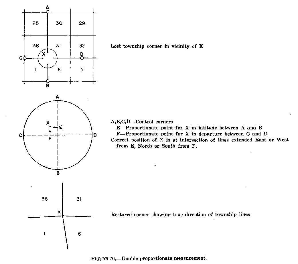
Double Proportionate Measurement
5-25. The term "double proportionate measurement" is applied to a new measurement made between four known corners, two each on intersecting meridional and latitudinal lines, for the purpose of relating the intersection to both.
In effect, by double proportionate measurement the record directions are disregarded, excepting only where there is some acceptable supplemental survey record, some physical evidence, or testimony that may be brought into the control. Corners to the north and south control any intermediate latitudinal position. Corners to the east and west control the position in longitude. One identified original corner is balanced by the control of a corresponding original corner on the opposite side of a particular missing corner which is to be restored. Each identified corner is given a controlling weight inversely proportional to its distance from the lost corner. Lengths of proportioned lines are comparable only when reduced to their cardinal equivalents. The method may be referred to as a "four-way" proportion. The method of double proportionate measurement is generally applicable to the restoration of lost corners of four townships and of lost interior corners of four sections.
5-26. In order to restore a lost corner of four townships, a retracement will first be made between the nearest known corners on the meridional line, north and south of the missing corner, and upon that line a temporary stake will be placed at the proper proportionate distance; this will determine the latitude of the lost corner.
Next, the nearest corners on the latitudinal line will be connected, and a second point will be marked for the proportionate measurement east and west; this point will determine the position of the lost corner in departure (or longitude).
Then, through the first temporary stake run a line east or west, and through the second temporary stake a line north or south, as relative situations may determine; the intersection of these two lines will fix the position for the restored corner.
Figure 70 illustrates the plan of double proportionate measurement. Points A, B, C, and D represent four original corners which will control the restoration of the lost corner X. On the large scale diagram the point E represents the proportional measurement between A and B, and similarly, the point F represents the proportional measurement between C and D. The point X satisfies the first control for latitude and the second control for departure.
5-27. A lost township corner cannot safely be restored, nor the boundaries ascertained without first considering the field notes of the four intersecting lines. It is desirable also to examine the four township plats. In most cases there is a fractional distance in the half-mile to the east of the township corner, and frequently in the half-mile to the south. The lines to the north and to the west are usually regular, with quarter-section and section corners at normal intervals of 40.00 and 80.00 chains, but there may be closing-section corners on any or all of the boundaries so that it is important to verify all distances by reference to the field notes.
5-28. Lost interior corners of four sections, where all the lines therefrom have been run, will also be reestablished by double proportionate measurement. The control for such restoration will not extend beyond the township boundary. If the controlling corner on the boundary is lost, that corner must be reestablished beforehand.
5-29. Where the line has not been established in one direction from the missing township or section corner, the record distance will be used to the nearest identified corner in the opposite direction.
Thus, in figure 70, if the latitudinal line in the direction of the point D has not been established, the position of point F in departure would have been determined by reference to the record distance from the point C; the point X would then be fixed by cardinal offsets from the points E and F as already explained.
Where the intersecting lines have been established in only two of the directions, the record distances to the nearest identified corners on these two lines will control the position of the temporary points; then from the latter the cardinal offsets will be made to fix the corner point.
An index correction for average error in measurement, if applicable, should be made in applying these two rules (see section 5-45). What is intended by record distance is the measure established in the original survey. Experience and good judgment are required in applying the rules. If the original survey was carelessly executed, no definite standard can be set up as representing that survey. On the other hand, the work may have been reasonably uniform within its own limits, yet inaccurate with respect to exact base standards. It is the consistent excess or deficiency of the original work that is intended here, if that can be determined within practical limits. Otherwise the only rule that can be applied is that a record of 80.00 chains in distance means just that by exact standards, true horizontal measurement.
Figure 70. - Double proportionate measurement. (See page 135 of the Manual)
5-30. The term "single proportionate measurement' is applied to a new measurement made on a line to determine one or more positions on that line.
By single proportionate measurement the position of two identified corners controls the direction of that line. The method is sometimes referred to as a "two-way" proportion, such as a north-and-south proportion or an east-and-west proportion. Examples are a quarter-section corner on the line between two section corners, all corners on standard parallels, and all corners occupying intermediate positions on a township boundary line.
5-31. In order to restore a lost corner on a line by single proportionate measurement, a retracement is made connecting the nearest identified corners on the line. These corners control the position of the lost corner. Control corners are usually corners established in the original survey of the line. The lost corner is then reestablished at proportionate distance on the true line connecting the recovered corners. Proper adjustment is made on an east and west line to secure the latitudinal curve. Any number of intermediate lost corners may be located on the same plan.
5-32. Restorations of lost corners of standard parallel are controlled by the regular standard corners. These include the standard township, section, quarter-section, and sixteenth-section corners, and meander corners, and also closing corners which were originally established by measurement along the standard line as points from which to start a survey.
Lost standard corners will be restored to their original positions on a base line, standard parallel, or correction line, by single proportionate measurement on the true line connecting the nearest identified standard corners on opposite sides of the missing corner or corners, as the case may be.
5-33. Corners on base lines are regarded the same as those on standard parallels. In the older practice the term "correction line" was used for what has later been called the standard parallel. The corners first set in the running of a correction line are treated as original standard corners. Those that were set afterwards at the intersection of a meridional line are regarded as closing corners.
5-34 All lost section and quarter-section corners on the township boundary lines will be restored by single proportionate measurement between the nearest identified corners on opposite sides of the missing corner, north and south on a meridional line, or east and west on a latitudinal line.
5-35. Two sets of corners have been established on many township lines and on some section lines. Each set applies only to sections on its respective side of the line. Which corners control the restoration of a lost corner will depend on how the line was surveyed. Three common cases are discussed:
(1) Where both sets of corners have been established by measurement along the line in a single survey, each corner controls equally for both measurement and alignment.
(2) Where a single set of corners was established in the survey of the line and closing corners were subsequently established at intersection of section lines on one side, the corners first established control both the alinement and the proportional measurement along the line. The original quarter-section corners nearly always referred to sections on only one side of the line after the closing corners were established on the other side. The quarter-section corners for sections on the side to which the closing corners refer were not established in older surveys. The correct positions are as protracted on the plat of those sections. (See also section 50-41, Closing Corners.)
(3) Sometimes one set of corners was established for one side of the line, and a second set of corners was established for the other side in the course of a later retracement.
The line is regarded as having been fixed in position by the senior survey unless that survey was officially superseded. If both sets of corners are recovered, a junior corner lying off the line is treated in the same manner as a closing corner insofar as the alinement is concerned. Since it was established in the course of a retracement reporting the most recent measurement of the line, a junior corner properly can be used for control in restoring a lost corner of the line insofar as measurement is concerned. This procedure is not advisable where the corner is far off line because a bearing in the connecting section line would change its true position relative to other corners of the line. That condition can only be shown by retracing enough of the connecting section line to determine its bearing. Where there has been extensive loss of corners, particularly the senior corners, the existent junior corners may also constitute the best available evidence of the line itself. In such a case they will exercise control for both measurement and alinement.
On rare occasions the second surveyor patently established a completely separate line and thereby created a hiatus or overlap. Each set of corners would then control only its respective line. Where complications develop, the surveyor should report to his supervising office the identity and correlation of corners or other evidence recovered before restoring the lost corners. Each such case must be considered individually. The same instruction applies to lines on which the original corners have become angle points and which therefore may have three sets of corners.
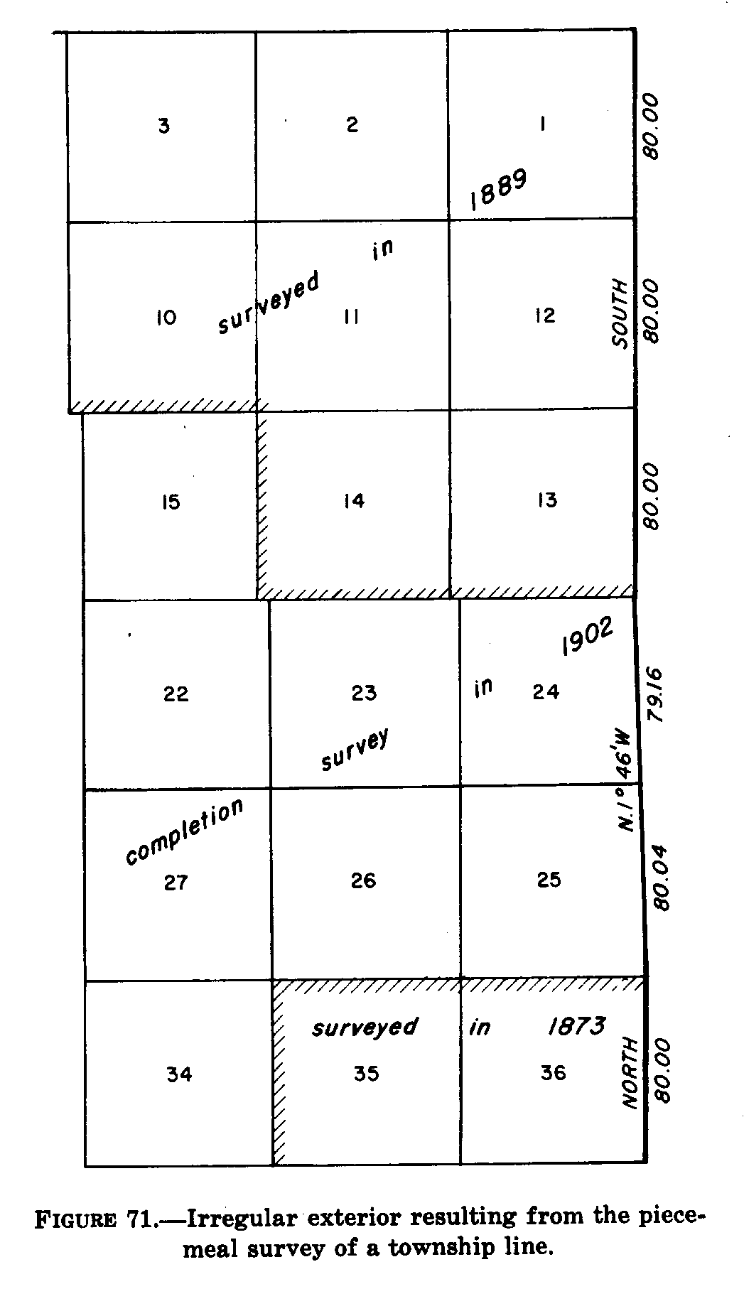
5-36. Some township boundaries, not established as straight lines, are termed "irregular" exteriors. Parts were surveyed from opposite directions and the intermediate portion was completed later by random and true line, leaving a fractional distance. Such irregularity follows some material departure from the basic rules for the establishment of original surveys. A modified form of single proportionate measurement is used in restoring lost corners on such boundaries. This is also applicable to a section line or a township line which has been shown to be irregular by a previous retracement. Figure 71.
In order to restore one or more lost corners or angle points on such irregular exteriors, a retracement between the nearest known corners is made on the record courses and distances to ascertain the direction and length of the closing distance. A temporary stake is set for each missing corner or angle point. The closing distance is then reduced to its equivalent latitude and departure.
Figure 71.
- Irregular exterior resulting from the piece-meal survey of a township
line.
(See page 137 of the Manual)
On a meridional line the latitude of the closing distance is distributed among the courses in proportion to the latitude of each course. The departure of the closing distance is distributed among the courses in proportion to the length of each course. That is, after the excess or deficiency of latitude is distributed, each temporary stake is moved east or west an amount proportional to the total distance from the starting point.
On a latitudinal line the temporary stakes should be placed to suit the usual adjustments for the curvature. The departure of the closing distance is distributed among the courses in proportion to the departure of each course. Then each temporary stake is moved north or south an amount proportional to the total distance from the starting point.
Angle points and intermediate corners will be treated alike.
5-37. Another exception to the usual application of single proportionate measurement is occasionally important. There may be persuasive proof of a deflection in the alinement of the exterior, though the record shows the line to be straight. For example, measurements east and west across a range line, or north and south across a latitudinal township line, counting from a straight-line exterior adjustment, may show distances to the nearest identified subdivisional corners to be substantially long in one direction and correspondingly short in the opposite direction. This condition, when supported by collateral evidence, would warrant an exception to the straight-line or two-way adjustment because the evidence outweighs the record. The rules for a four-way or double proportionate measurement would then apply here, provided there is conclusive proof.
5-38. All lost quarter-section corners on the section boundaries within the township will be restored by single proportionate measurement between the adjoining section corners, after the section corners have been identified or relocated.
In those cases where connections from the lost quarter-section corner to other regular monuments of the line nearer than the section corners have been previously noted, these will ordinarily assume control in the restoration. Such monuments may include another quarter-section corner, minor subdivision corners, a meander corner, an angle point, or a line tree, any of which may have been established when the line was previously surveyed or resurveyed. (See also under section 5-41, Closing Corners.)
5-39. "Half-Mile Posts," Alabama and Florida
In the early practice in parts of Alabama and Florida, so-called "half-mile posts" were established at distanced of 40 chains from the starting section corner. The term was applied where the line might be more or less than an exact 80 chains in record length, and where by later methods the latitudinal lines have been run as "random and true." The practice contemplate that in some cases these subdivisional lines be run in cardinal directions to an intersection, where the next section corner would be placed, and either or both lines might be more or less than 80 chains in length. In some cases the section corners were placed across the township at intervals of 80 chains on one of the cardinal lines, and the other lines were run on random only. On the first plan the "half-mile post" would not be at midpoint unless the line turned out to be 80 chains in length. On the second plan the "half-mile post" on the lines first run would be in true position for the quarter-section corner, but on the lines last run they would usually not be on true line, nor at mid-point.
In both cases field notes were written showing a true line direction and midpoint distance for a quarter-section corner. This was done to meet the object that the "half-mile post" did not satisfy the requirements of law, but the true line was not actually run on the ground, nor was a monument constructed at midpoint. In these cases only the true line field notes need be regarded if the evidence of the "half-mile post" has disappeared; but where the latter can be identified the point must be given proper weight for control. Each set of field notes requires its individual consideration, as the practices were not uniform even in the same surveying district.
The applicable rules for the restoration of the true line midpoint positions for the quarter-section corners in the above practices are derived from the Act of February 11, 1805 (R.S. 2396), which requires that "the corners of half and quarter sections, not marked on the surveys, shall be placed as nearly as possible equidistant from two corners which stand on the same line."
The rules may be stated specifically as follows:
(1) In case the "half-mile post" and quarter-section corner are recorded as being at a common point, the identified "half-mile post" will be restored as the quarter-section corner.
(2) If there is evidence of the position of the section corners in both directions, and if the record leaves doubt as to the establishment of the "half-mile post" on the true line, the quarter-section corner will be monumented at midpoint on the true line, disregarding the record of the "half-mile post."
(3) In the absence of evidence at one or both section corners and where the record leaves doubt regarding the running and marking of the true line, the "half-mile post" will be employed on a north and south line for the control of the latitude of the quarter-section corner, or on an east and west line for control of its position in departure, using the record correction for distance. The alinement of the section boundary and the position of the quarter-section corner on the true line will be adjusted to the location of the two section corners after the double proportionate measurements have been completed.
(4) Where the field notes show proper location for alinement and record correction for distance, the "half-mile post" will be employed for the full control of the position of the quarter-section corner, and for the restoration of the lost section corners. The position of the quarter- section corner in latitude on a north and south line, or in departure on an east and west line, will be ascertained by making use of the record correction for distance from the "half-mile post." The alinement from the position of the "half-mile post" to the point for the quarter- section corner will be determined by the position of the section corner to the south, if the record correction for distance is to be made to the north; the section corner to the north will be used if the record correction for distance is to be measured to the south; and similarly on east and west lines.
(5) The evidence of the "half-mile post" will not be destroyed.
Lost meander corners, originally established on a line projected across the meanderable body of water usually will be relocated by single proportionate measurement. However, the facts must be considered with regard to the specific problem in hand.
under favorable conditions a lost meander corner may be restored by treating the shore line as an identified natural feature. In the event of extensive obliteration of the original corners within the locality this position may be preferable to one obtained by proportionate measurement carried from a considerable distance.
In extreme cases restoration by adjustment of the record meander courses to the bank or shore line may be indispensable to the reconstruction of the second boundaries. Granting extensive obliteration, where there has been obvious stability to the bank or shore line, or absence of appreciable changes by erosion or accretion, the record meander courses and distances may be conformed to the salients and angles of the physical bank or shore line. If found satisfactory, that restoration may be regarded as the most suitable position for the meander corner. This may give a location in both latitude and departure, in latitude only, or in departure only.
Occasionally, it can be demonstrated that the meander corners on opposite banks of a wide river were actually established as terminal meander corners even though the record indicates the line was projected across the river. If the evidence outweighs the record, a lost meander corner in such a case will be relocated by single point control. (See section 5-45, Original Control.)
A lost closing corner will be reestablished on the true line that was closed upon, and at the proper proportional interval between the nearest regular corners to the right and left.
In order to reestablish a lost closing corner on a standard parallel or other controlling boundary, the line that was closed upon will be retraced, beginning at the corner from which the connecting measurement was originally made. A temporary stake will be set at the record connecting distance, and the total distance and falling will be noted at the next regular corner on the line on the opposite side of the missing closing corner. The temporary stake will then be adjusted as in single proportionate measurement.
A recovered closing corner not actually located on the line that was closed upon will determine the direction of the closing line, but not its legal terminus. The correct position is at the true point of intersection of the two lines.
The new monument in those cases where it is required will always be placed at the true point of intersection. An off-line monument in such cases will be marked AM (for amended monument) and will be connected by course and distance. The field notes of the closing line will include a full description of the old monument as recovered and a clear statement that the new monument is set at the true point of intersection.
When an original closing corner is recovered off the line closed upon and the new monument is established at the true point of intersection, the original position will control in the proportionate restoration of lost corners dependent upon the closing corner. In a like manner the positioning of sixteenth-section corner(s) or lot corner(s) on the closing line, between the quarter-section corner and the closing corner, will be based on the measurement to the original closing corner.
A closing corner ordinarily is not used as control corner in restoring a lost corner of the line closed upon. However, where a previous obviously careful retracement has explicitly shown the relative positions of all the corners on the line, including the closing corners, the latter may exercise control to the same limited extent as corners of a junior survey. Section 5- 35(3).
Closing corners in some cases have been established where a line of the survey crosses previously surveyed claim lines. (See section 3-71, Closing Section Lines.) A crossing closing corner established to mark the intersection of a junior line crossing an existing senior line, if it is not at the true intersection, establishes only the direction of and a point on the junior line. In effect, such a crossing closing corner has the same standing as an angle point on the junior survey; it has no effect on the senior line.
A closing corner set to mark the intersection of a resurvey of a junior crossing line with a senior line has no standing if it does not, in fact, mark the true intersection. The true point remains the actual intersection of straight lines connecting the two pairs of controlling corners. Otherwise, the monument can serve only as a control point for the reestablishment of lost control corners on the junior line.
A different problem must be faced where the record tie from a closing corner to a corner of the line closed upon is fictitious, grossly in error, or in some way irreconcilable. If the closing corner in such a case is recovered, it will normally control the direction of the closing line regardless of its disagreement with the record. If there is no evidence whatever of the closing corner, and ample proof that the closing was not made as called for in the field notes, the closing corner should not be restored without verifying the nearest authentic closing on either side. The restoration will then be made by the method most nearly in harmony with the official procedure to be adopted should have official sanction prior to remonumentation of the lines.
5-42. The foregoing are the general rules for the restoration of lost or obliterated corners. The special cases that are hereinafter cited with respect to broken boundary lines and limited control do not have wide application and do not have similar importance excepting under those conditions, and as explained in the succeeding text.
The preceding instructions will be applicable in the large majority of cases. If there seems to be some difficulty or inconsistent result, a careful check should be made of the record data. The special instructions for the original survey, the plat representation, or some call of the field notes may clarify the problem upon further study. This research assumes a large importance in the more difficult problems of the recovery of an old line or boundary.
It is not intended to disturb satisfactory local conditions with respect to roads and fences. The surveyor has no authority to change a property right that has been acquired legally, nor can he accept the location of roads and fences as evidence prima facie of the original survey. Something is needed in support of these locations. This will come from whatever intervening record there may be, the testimony of individuals who may be acquainted with the facts, and the coupling of these things to the original survey.
Other factors to be considered are the rules of the State law and the State court decisions, as distinguished from the rules laid down by the Bureau of Land Management (the latter applicable to the public land surveys in all cases). Under State law in matters of agreement between owners, acquiescence, or adverse possession, property boundaries may be defined by roads, fences, or survey marks, disregarding exact conformation with the original section lines. These may limit the rights as between adjoining owners.
In many cases due care has been exercised to place the property fences on the lines of legal subdivision, and it has been the general practice in the Prairie States to locate the public roads on the section lines. These are matters of particular interest to the adjoining owners, and it is a reasonable presumption that care and good faith would be exercised with regard to the evidence of the original survey in existence at the time. Obviously, the burden of proof to the contrary must be borne by the party claiming differently. In many cases there are subsurface marks in roadways, such as deposits of a marked stone or other durable material, that are important evidence of the exact position of a corner if the proof can be verified.
A property corner should exercise a regular control upon the retracement only when it was placed with due regard to the location of the original survey, or agreement is so close as to constitute the best available evidence.
5-43. Angle Points of Nonriparian Meander Lines. In some cases it is necessary to restore (or possibly to locate for the first time) the angle points, within a section, of the record meander courses for a stream, lake, or tidewater, which may be required under the special rules which are applicable to nonriparian meander lines.
In these cases the positions of the meander corners on the section boundaries are determined first. The record meander courses and distances are then run and temporary angle points are marked. The residual error is shown by the direction and length of the line from the end of the last course to the objective meander corner. The residual is distributed on the same plan as in balancing a survey for the computation of the areas of the lottings as represented on the plat.
The general rule is that the adjustment to be applied to the {latitude/departure } of any course is to be the resolved {latitude/departure} of the closing error as the length of the course is to total length of all the courses. Each adjustment is applied in a direction to reduce the closure. If the northings are to be increased, then the southings will be decreased. A line due east would then be given a correction to the north (in effect to the left); a line due west, also to the north (in effect to the right). Each incremental correction is determined and applied in proportion to the length of the line.
The field adjustments for the positions of the several angle points are accomplished simply by moving each temporary point on the bearing of the closing error an amount that is its proportion of that line, counting from the beginning. The particular distance to be measured at any point is to the whole length of the closing error as the distance of that point from the starting corner is the sum of the lengths of all the course. Figure 72.
The same principle is followed to plot lottings of dependently resurvey sections in their true relative positions when the record meander line and the true shoreline differ greatly because of distortion.
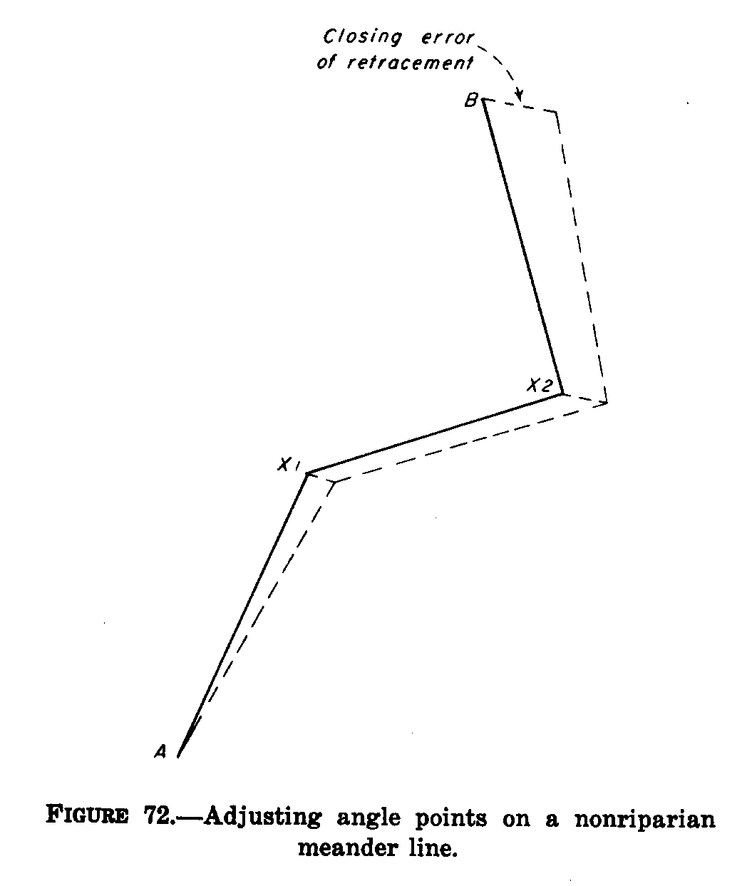
Figure 72. - Adjusting angle points
on a nonriparian meander line.
(See page 142 of the Manua)
5-44. Grant Boundaries. In many of the States there are irregular grant and reservation boundaries that were established prior to the public-land subdivisional surveys. In these cases the township and section lines are regarded as the closing lines. The grant boundary field notes may call for natural objects, but these are often supplemented by metes-and-bound descriptions. The natural calls are ordinarily given precedence, next the existent angle points of the metes-and- bounds survey. The missing angle points are then restored by uniformly orienting the record courses to left or right and adjusting the lengths of the lines on a constant ratio. Both angular and linear corrections are made in the direction needed to reduce the falling of the trial lines laid down according to the record.
The retracement of the grant boundary is begun at an identified corner. Calls for natural objects are satisfied and the existent angle points are recovered. Then, between the identified or acceptable points, the position of missing angle points is determined by these steps:
(1) Reduce the record courses and distances to the total differences in latitude and departure. Compute the direction and length of a line connecting the identified points.
(2) Determine the actual differences in latitude and departure between the same identified points by retracement. Compute the direction and length of the connecting line based on these figures.
(3) The angular difference of direction between the connection lines computed in (1) and (2) gives the amount and direction of the adjustment to apply to the record bearing of each intermediate course.
(4) The radio of the length of the line computed in (2) to that computed in (1) gives the coefficient to apply to the record length of each intermediate course.
After the adjustments are completed, additional search for evidence of the record markers should be made. The adjusted locations for the angle points are in the most probable original position, and a better check of collateral evidence is possible. If no further evidence is recovered, the adjusted points are then monumented.
In figure 73, A and B are identified points of the original boundary. It is desired to restore intermediate points T, S, R, J, I, H, and G, which have been temporarily marked at Tt, St, Rt, Jt, It, Ht, and Gt in conformation with the original record starting from point A. The record position of point B in relation to point A is designated Bt. The adjustment has been made in the four steps already described.
The same procedure may be followed whenever it is desired to retain the form of the traverse being adjusted, since the interior angles are unchanged and the increase or decrease in lengths of lines is constant. The adjustment may be likened to a photographic enlargement or reduction. Mechanically, this process requires that the record distances of the traverse legs between identified points be reduced or increased simultaneously with the rotation of the record bearings until the two identified points coincide.
Figure 73.
- Adjusting a grant boundary.
(See page 143 of the Manual)
5-45. Original Control
Where a line has been terminated with measurement in one direction
only, a lost corner will be restored by record bearing and distance, counting
from the nearest regular corner, the latter having been duly identified
or restored.
Examples will be found where lines have been discontinued at the intersection with large meanderable bodies of water, or at the border of what was classed as impassable ground.
An index correction for average error in the original measurement should be used, if appropriate, as discussed in section 5-29. Additionally, in cases where a retracement has been made of many miles of the original lines, between identified original corners, and there has been developed a definite angle from cardinal that characterizes the original survey, it is proper to make allowance for the average difference.
5-46. Experience, thoroughness, and good judgment are indispensable for the successful retracement and recovery of any survey when it reaches a stage of extensive obliteration. It is an axiom among experienced cadastral surveyors that the true location of the original lines and corners can be restored, if the original survey was made faithfully, and was supported by a reasonably good field-note record. That is the condition for which the basic principles have been outlined, and for which the rules have been laid down. The rules cannot be elaborated to reconstruct a grossly erroneous survey or a survey having fictitious field notes.
5-47. The records of official resurveys cover many special cases. The records in Washington include the special cases from all public-land States. These plats, field notes, reports of field examinations, office opinions, Departmental decisions, opinions from the Attorney General of the United States, and frequently court opinions and decrees are drawn upon when needed to assist the surveyor in situations that are new to his own experience. When the surveyor encounters unusual situations, or finds it difficult to apply the normal rules for the restoration of lost corners, he should report the facts to the proper administrative office. If it is determined that additional retracements are necessary, these may be provided for by supplemental instructions.