7-1. The detailed specifications for each survey are set out by the officer in administrative charge of the work in a written statement entitled "Special Instructions." The special instructions are an essential part of the permanent record of the survey, both as historical information and because they show that the survey was properly authorized. The immediate purpose is to outline the extent of the filed work and the method and order of procedure. Coupled with the Manual, the special instructions contain the technical direction and information necessary for executing the survey. Emphasis is given to any procedure unusual in application, but no lengthy discussion is required of procedures that are adequately covered in the Manual. The special instructions are written in the third person.
7-2. Shown below is the arrangement of subject matter in the special instructions. Italicized portions denote standard phraseology.
(1) Title: Special Instructions Group No. ___, (State)
(Nature of survey, and location by township, range, and meridian)
(2) Preliminary statement:
In the execution of the surveys included under Group No. ___, (State), the chief of field party is authorized and directed to make the described examination, retracements, reestablishment of points of control, surveys, and resurveys set out in these instructions. He will be guided by the Manual of Surveying Instructions, the provisions of the following special instructions, and such supplemental instructions as may be issued during the progress of the work.
(3) Authority
Cite departmental or bureau instructions or authorization, the request of another Federal agency having administrative jurisdiction over the lands whose survey is being requested, or any special act of Congress relating to the survey.
(4) Appropriation
The costs of the field and office work incurred in the execution of the survey, within approved official regulation, are payable from the appropriation: Give the title of the applicable appropriation, fund, or deposit, and cite the act of Congress under which a deposit has been received.
(5) Limit and Character of Work
Describe the lines to be surveyed by township, range, and meridian, with designation by section where only parts of townships are authorized. If the work involves other than original surveys, indicate the character of the fragmentary survey, the type of resurvey, or the nature of the field examination. Legal or technical questions related to the work may be pointed out here or in the part of the instructions dealing with methods, whichever is most appropriate. Similarly treated would be known facts concerning private rights that may be affected and directions for protecting those rights.
(6) History of Earlier Surveys
Each new survey, retracement, or resurvey is predicated on the surveys accepted previously. The pertinent existing surveys are reviewed in the special instructions with an explanation of known or presumed complications.
(7) Method and Order of Procedure
If the projected work is an extension of original surveys, it is taken up in the following order in the instructions:
(a) Standard parallels and guide meridians
(b) Township exteriors
(c) Subdivisions, including meander lines
(d) Subdivision of sections if included
The instructions for each township should be completed separately. If complications are anticipated, the surveyor should be informed what to expect and what methods to apply. References to Manual rules are made by chapter and section numbers, but the surveyor is expected to understand regular practices and to be familiar with the Manual as a reference guide in unusual cases. ; The burden of this should not be transferred to the special instructions.
If the work involves other than original surveys, detailed specifications are stated for required examinations, fragmentary surveys, resurveys, topographic surveys, or special monumentation. There follows in this chapter a discussion of how the usual types of special surveys are treated.
Where precautions need to be taken for the preservation of esthetic values in the environment, such as the elimination of blazing on the lines or the limitation of vehicular use, the special instructions should so state. Additionally, the surveyor should be directed to exercise care in situations not covered by the instructions.
(8) Diagrams and Supplemental Data
In the case of original surveys a diagram constructed on a scale of 80 chains to an inch or larger should be furnished as a part of the instructions. The assigned work is usually shown by dashed lines and the adjoining previous surveys by solid lines. The diagram should indicate the directions and lengths of lines of the established surveys within two miles of the new assignment. Outlying areas protracted as though surveyed on the previous plats should always be shown.
A notation should be made in the instructions that copies of the plats and field notes of previous surveys pertinent to the assigned work will be furnished at the time of field assignments.
Known claims, improvements, or monuments of other official surveys should be noted in the instructions.
When pertinent to the survey, the special instructions are supplemented by a status report, usually in the form of a diagram, showing disposals and withdrawals in the area to be surveyed or resurveyed. Streams upon which withdrawals for power sites or other purposes have been or may be made, and streams, ridges, or divides which constitute the boundaries of reserves, should be specified.
There should be supplied with the special instructions a list of available topographic maps, aerial photographs, and other data showing important map features. Any required additional mapping to be done in the field should be indicated.
(9) Field Notes, Plats, and Reports
The special instructions should include directions for the preparation of the field notes and point out the parts of the returns that will require special attention in the field. If a preliminary report or diagram is to be submitted during the progress of the field work, the instructions should so state. Special lottings or other unusual matters that are to be considered when the final returns are prepared should be specified.
Direction will be given to return for official use the special instructions and other papers that belong with the official record, data added in the field, and field computation sheets.
(10) Modification of Instructions
The special instructions should direct the chief of field party to report promptly conditions that call for additional or modified instructions together with a recommended procedure.
7-3. The special instructions are ordinarily prepared and signed by the technical officer in direct administrative charge of the particular surveying program. Approval of the instructions is by the office head in administrative charge of the area where the survey is made, or as delegated by current regulations. The date of the instructions and date of approval are always shown.
7-4. Special surveys are surveys that involve unusual applications of or departures from the rectangular system. They often carry out the provisions of a special legislative act. A particular category of special surveys has to do with various types of water boundaries. In some cases the special instructions merely expand the methods outlined in chapter III. In the more complicated special surveys the methods must be carefully detailed.
The following discussion of the several types of special surveys illustrates what is to be emphasized in the special instructions for each.
7-5. Special surveys may involve areas of land that are not aliquot parts of sections but are designated as lots or tracts. In common usage the term "tract" is applied to an expanse of land of no particular size, often irregular in form. In modern public land surveys the term is used specifically to mean a parcel of land that lies in more than one section or that cannot be identified in whole as a part of a particular section. It is properly described by tract number and township. Tracts within a township are numbered beginning with 37 or the next highest unused numerical designation to avoid confusion with section numbers.
7-6. Unless tracts have been segregated in the course of an independent resurvey, in which case they are treated as described under that subject, an irregular parcel lying entirely with a surveyed section should be designated as a lot of that section. "Small tracts," when not aliquot parts of sections, are designated as lots wherever they can be identified as parts of a section. The description is by lot, section, and township.
7-7. Except in independent resurveys, or if the proper name is "Tract __________," an area of non-public land should be designated as a parcel, not as a lot or tract, when a special designation is necessary for identification. To distinguish among several parcels, they may be called "Parcel A," "Parcel B," and so on.
7-8. The need for subdivision of sections and any usual methods required are brought out in the special instructions. Examples are Indian allotment surveys, subdivisions within reclamation projects, the determination of boundaries between intermingled public and patented lands within a section, the subdivision of sections into "small tracts," and various fragmentary surveys needed to mark the boundaries of the remaining public lands. In complicated cases the subdivision of sections may be advisable to avoid the possibility of an incorrect local survey.
7-9. Nearly always the subdivision-of-section lines are run out in accordance with the showing of the official plat. An uncommon exception is when a disposal has been made of a parcel whose description clearly differs from the lottings or aliquot parts represented on the plat.
7-10. The customary lottings are often not shown on plats of very old surveys. A determination of what the disposals were intended to convey can then be made only be reference to the record of the disposals themselves. Furthermore, in some of the old surveys quarter-section corners were not established on all true lines of the survey. Instead, the record shows that half-mile" points were marked on the random line and not corrected to the true line midpoints. All such unusual problems should be brought out in the special instructions, as the diversity of the questions arising and the limited applicability of the answers precludes extended Manual treatment. (See Half-Mile Post, Alabama and Florida, section 5-39).
7-11. Where special methods are unavoidable, they should be made to conform as nearly as possible with the rules for the subdivision of sections discussed in chapter III. The special instructions should specify the procedure when the areas do not conform to the rectangular system of surveys.
7-12. If a section is subdivided, the center quarter-section corner is established and monumented. if a quarter section is subdivided, all sixteenth-section corners are established and monumented. Monuments of lower order are established where necessary to mark the actual boundaries of the minor subdivisions involved. Only the required boundaries need be surveyed within the sixteenth section, but, if this method is used, such lines must be connected to and balanced between corners on the sixteenth-section lines.
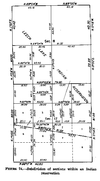
Figure 74. - Subdivision of sections within an Indian reservation. (See page 160 of the Manual)
7-13. Figure 74 illustrates the subdivision of sections within an Indian reservation. This includes a dependent resurvey of the section lines and the reservation boundary, followed by the subdivision of sections as needed for administrative purposes.
7-14. Under the general and special allotment acts it has sometimes been the practice to make awards in units of less than the usual quarter-quarter section. The Indian bureau is expected to advise upon the appropriate act to be employed and the configuration and extent of the subdivision. When a proposed allotment is described by metes and bounds, it is assigned a lot number within each of the one or more sections involved. The lot numbers are independent of the serial allotment numbers.
Status diagrams which show the Indian allotment awards should always be furnished the special instructions.
7-15. When the sections to be subdivided border meandered bodies of water, the shore line may have been changed materially by erosion, accretion, the construction of a dam, or the recession of the water. If it is desirable to remeander the body of water in order to show the true conditions at the date of the subdivision of the sections, the plat should show new lottings for unpatented lands within the fractional sections. (See section 9-81 and illustration, figure 88).
In a situation which involves erroneous original meanders the rules to be followed will be found under "Water Boundaries" of this chapter. The need for work of this type should be brought out clearly in the special instructions for the survey or in supplemental instructions if the facts are developed after the survey has been commenced.
7-16. Metes-and-bounds surveys are required to define the boundaries of irregular areas of land which are not conformable to legal subdivisions. This type of survey may involve mineral claims, small-holding claims, private-land grants, forest-entry claims, national parks and monuments, Indian reservations, lighthouse reservations, trade and manufacturing sites, homestead claims in Alaska, or the like.
The survey procedure is similar for each type of claim, grant, or reservation having irregular boundaries. A monument is required at each angle point of the boundary. The angle points are given serial numbers beginning with No. 1 at the initial point. Monuments on the boundary should not be more than 45 chains apart. When the lengths of courses exceed that distance, witness points are established on the tops of ridges, at streams, trails, roads, or other accessible and prominent places. In the survey of boundaries of large grants or reservations, mile corners are established in addition to the angle points and witness points. The plan of monumentation should be designated in the special instructions for the survey.
Metes-and-bounds surveys located upon surveyed land are connected to a regular corner of the subdivisional survey. If the area surveyed lies entirely within a surveyed section, it should be designated as a lot of that section and be numbered accordingly. If the location is within an unsurveyed township, the special instructions should call for the running of a connecting line to an established corner, the establishment of a location monument, or the determination of the geographic position of the initial point.
Nonriparian boundaries of these irregular areas, as called for by the law or executive order creating them, have sometimes been partly or entirely located along a natural boundary such as a watershed. Boundaries of this sort are normally winding, and it should be understood that they are technically defined by the natural feature and not by the straight lines between angle points monumented in a survey. Northern Pacific Railway Co. v. United States, 227 U.S. 355 (1913).
7-17. R.S. 2380 and 2381 (43 U.S.C. 711, 712) and numerous special acts make provision for the executive withdrawal of public lands for the executive withdrawal of public lands for townsite purposes. A townsite survey, in public-land surveying practice, is a survey made within one or more regular units of the township subdivision by which the land is divided into blocks, streets, and alleys as a basis for the disposal of title in village or town lots.
Ordinarily special instructions are prepared for a preliminary reconnaissance of the townsite and for the resurvey and subdivision of sections which may be necessary. These are followed by supplemental instructions based on the findings of the examination and providing for the townsite survey proper.
7-18. Townsite surveys fall into two general classes, those with few or no prior improvements and those where villages or towns already exist. Occasionally a townsite may be planned in connection with some Federal project where the survey must fit special requirements already set up. Whatever class the townsite falls in, a study of approved townsite plats with similar elements is helpful in planning. A visit to some of these developed areas may be worth-while to show good and bad planning clearly.
7-19. Consideration of every facet of townsite planning is beyond the scope of this Manual. There may be need for consultation with specialists in architectural and industrial planning, landscaping, and various branches of city engineering such as water supply, sewerage, street, highway, and railroad location. Provision is needed for public school grounds, other public buildings, and park areas. All these things are interdependent, and wherever possible, local planning bodies should be asked to present plans which meet with zoning requirements. The planner should also refer to some of the many books on the subject of town planning.
7-20. The rules that follow set out the minimum specifications for the running and measuring of the lines, the monumentation, and the elements of plat construction by which the blocks and lottings may be identified. The detail of the plan should be set out in the special instructions.
The character of the area - the topography, its location, and whether it is a new townsite or an addition to an old one - to a large extent determines the detail of the street and block system. A topographic survey is of value in ascertaining the layout best suited; the special instructions should call for the appropriate contour interval. Wherever practicable, especially where there are existing improvements, photogrammetry should be employed in the preliminary examination with panelled boundary monuments incorporated in the aerial control.
7-21. In the typical townsite the block dimensions are usually between 300 and 400 feet. The principal streets are usually made 80 feet in width, though frequently as much as 100 feet where greater width is called for. The less important intersecting streets, though narrower, are seldom given a width of less than 60 feet.
The normal frontage of the lots is 50 feet. Unless conditions require a special plan, the whole system is laid out on cardinal. The blocks are given serial numbers, usually beginning with the northeast block and proceeding with the numbers alternately to the west and to the east. The lots are given serial numbers within the block.
7-22. The foot unit is employed in townsite surveys, and long steel tapes graduated in that unit are furnished for the purpose. Lengths of lines are reduced to the horizontal. In most cases the necessary accuracy can be secured only with the use of a spring balance for the maintenance of the proper tension and with allowance for temperature corrections to the degree at which the tape is standard.
7-23. The field traverse of the townsites will ordinarily be made to close within an error not to exceed 1/5000, and never to exceed 1/2000. The determined lengths of lines and their bearings are balanced to secure a perfect closure for the data which are to be carried to the plat. Instrumental accuracy is obtained by the method of repetitions in turning the angles. These data should leave no discrepancy whatever in any calculated position, whether working from one monument to another, or between any two points.
7-24. If the proposed townsite is in an area already surveyed, great care should be exercised to identify the original section lines and to subdivide the section or sections in the proper legal manner to ascertain the assigned townsite boundaries. Permanent monuments are placed at each angle of the townsite boundary. These may be the regulation 2«-inch iron post or a tablet seated in a concrete post, 3 feet long and at least 8 inches square in cross section. Markings consist of the usual subdivisional identification marks, the capital-letter initials of the townsite name, and the letters "TS" in the appropriate quadrant.
7-25. The boundary streets are laid out first, then the other streets, blocks, and lots. Permanent control monuments are established and connecting line measurements made as necessary to afford an exact relocation of any point. All data, including true bearings and deflection angles, connecting lines, and dimensions of streets, blocks, and lots are carried to the townsite plat. Their sufficiency may be tested by the ease with which the position of any given point can be ascertained and the area of any lot can be calculated. if there are curved lines, the curve elements are shown on the plat.
7-26. Permanent monuments are placed at the intersections of the street center lines and connections made to the block corners to insure a ready restoration of any block corner which might be obliterated. The 2«-inch iron post or a tablet seated in a concrete post, 24 inches long and at least 6 inches square in cross section may be used. These should be sub-surface monuments, placed as much as a foot below the probable grade line of the street and marked only for the point of intersection.
Where the street center-line intersections are intervisible, the markers may be placed at alternate intersections. Otherwise, a marker is placed at each intersection.
7-27. Where the street center-line intersection is not marked, the adjacent block corners are monumented with the regulation post set with the top flush with the ground and with a guard stake. If the intersection is monumented, durable markers such as galvanized iron pipes are set at the block corners and the front corners of the lots. These points are always monumented. The lot corners are set only on the block lines. Only the monuments at block corners are marked with the appropriate numbering. A permanent monument is placed at each angle point within the block boundary, when irregular, and at each point of curvature and point of tangency if the line of the block has been placed on a curve.
7-28. Lengths of lines and all angles or bearing are determined in the field for all irregular blocks and lots. In such cases both the side lines and back lines are always measured in the field. The dimensions are carried to the plat wherever needed, as when the lines cannot readily located by the method of intersections.
7-29. Photogrammetry is especially useful in showing the irregular layout of an existing town or village. With the extent of the improvements known, the streets, blocks, and lots can be laid out on a trial basis on the photographs in order to determine the best plan. If the coordinates of lot corners, street center lines, monuments, and other points of significance are to be determined, the work should be done with a first order plotting instrument or by analytical methods. A sufficient number of positions are marked in advance of photography to reduce the work of transit and tape to a minimum.
7-30. The field notes of the townsite survey described the resurvey of the old section lines, the restoration of any needed corners, the subdivision of sections, and the controlling monuments. All important connecting lines and measurements between the boundary monuments and the corners of the block lines, or to the permanent monuments marking the street center lines adjacent to the boundaries, are included. The plan followed in the townsite survey is explained and a general statement made as to the monumentation. Beyond this, the further detail of all directions and lengths of lines is carried to the plat but omitted in the field note record. If any improvements are unavoidably left in conflict with the townsite layout, the information is brought out in the field notes but omitted from the plat.
7-31. Townsite plats are usually published at a scale of 200 feet to an inch, but they are frequently drawn at a somewhat larger scale, subject to reduction when published. A marginal diagram is usually supplied in order to show the relation of the townsite boundaries to the section lines, with lengths of lines here given in the chain unit. Tenths and hundredths of links are used where appropriate for making reduction to the lengths of lines shown on the main drawing.
On the main drawings all lengths of lines are shown in the foot unit, with tenths where needed. All directions and lengths of lines, intersection angles, and connecting lines to monuments are given on the plat with a view to the location of any point by calculation from the points of permanent control. This facilitates ready calculation from the plat of the area of any individual lot.
The drawing shows the block and lot numbers, areas of lots to the nearest square foot, and the designation of streets by letters, numbers or names. In drafting the data for the regular blocks some of the figures which would be applied in each lot of the block may be omitted if it is left clear within the block that the lottings are regular for dimension and area.
All permanent monuments are shown on the main drawing and connecting data supplied. The widths of the streets should be plainly shown, but not repeated needlessly. Where all of the lots in a block are of the same dimensions, it is sufficient to show the measurements only along the block lines. A memorandum is supplied to note the general plan of monumentation, with an outline description of the monuments.
If there are reservations for public-school grounds, or of grounds for other public buildings or parks, the provision should be stated in the special instructions. The designated blocks are shown upon the plat, numbered regularly and titled, but not subdivided.
Reference should be made to chapter IX for the usual requirements regarding the title and the certificates which are to appear on the townsite drawing.
7-32. The Act of June 1, 1938, (52 Stat. 609), as amended by the Act of June 8, 1954 (68 Stat. 239; 43 U.S.C. 682a), provides for the sale or lease of small tracts not exceeding five acres. The survey made to delineate the tracts differs from a townsite survey in that it normally follows a pattern of progressional subdivision down to the desired lot sizes without block designations or the segregation of streets and alleys. Regulations provide for reserving rights-of-way in the patents or leases.
7-33.The first requirement of the survey is the establishment or reestablishment of the section boundaries. The ensuing subdivision into small tracts should not be made without a study of the terrain. under favorable circumstances the section may be subdivided into legal subdivisions and thereafter into lesser aliquot parts. However, it is sometimes necessary to depart from normal subdivision lines in order to make the tract layout compatible with drainage features, existent roads, and improvements on adjoining lands.
7-34. Aerial photographs and topographic maps are helpful in devising a suitable plan of subdivision. A preliminary survey and development of a topographic map may be necessary. The small tracts might then take an irregular form so to fit the topography. While the individual parcels are called "small tracts," they are designated on the official plat as lots when not describable as aliquot parts of the section. If the survey is in the vicinity of urban or suburban development, the plan should be discussed with local officials as to suitability.
7-35. Small-tract surveys should always be executed within a closure limit of 1:2560 in either latitude or departure. If stricter limits are desirable in an urban or suburban area, provision will be made in the special instructions.
7-36. Al corners of each lot should be monumented. Regulation monuments are used on section boundaries and on subdivisional lines down to 1/64 section lines. Further monumentation may be with approved materials called for in the special instructions such as iron pipes, rods, or angles. On an irregular lotting scheme regulation monuments should be used at approximate intervals of ten chains, preferably at intervisible points. Where all corners of an individual lot can be established on the lines of larger subdivisions, the minor subdivisional lines need not be surveyed.
7-37. The final field notes contain the regular record of the survey or resurvey of the section lines and subdivisional lines to the extent of all actual field surveys. The plat shows all data relating to established lines and measurements. Lot lines and measurements developed by protraction should be appropriately dashed and shown parenthetically. Bearings should be shown to 15" of angular value and distances to tenths of links. Each "tract" is assigned an appropriate lot number, and the area is shown to hundredths of an acre.
7-38. Topographic detail on the plat should be kept to a necessary minimum and subordinated to the base data. Anticipated new rights-of-way for road and public utility purposes, to be reserved in the lease or conveyance of the lots, need not be shown. It may be desirable to show the scheme of corner monumentation on the plat by appropriate symbols.
7-39. A mineral segregation survey is metes-and-bounds survey made to define the limits of non-mineral public land adjoining one or more mining claims and to supply data for lotting the non- mineral land against the claims. Although a necessary part of the survey is to ascertain the boundaries and position of the mining claims, it is not a mineral survey and confers no permanent rights upon the mineral claimant. If the subsisting records furnish the information necessary for a proposed segregation of mineral claims from the non-mineral public lands, no mineral segregation survey is required.
7-40. Mineral segregation surveys fall into two classes:
(1) Where the record of official mineral surveys is faulty or fails to locate the claims accurately with respect to the rectangular net. Proper segregation usually requires the resurvey of section boundaries with connections to the mineral surveys.
(2) Where unsurveyed mining claims require segregation from land embraced in a pending administrative action. The field work consists of metes-and-bounds surveys of the mining claims, with connections to corners of the public land net, and the resurvey of section boundaries.
7-41. Where regular conditions are found, the mineral segregation survey consists only in running not less than two connecting lines from identified corners of the rectangular survey to a corner or corners of the mineral location, followed by a survey of the outboundaries of the mining claim or group of claims.
Monuments are placed at the angle points along the boundary of the mining claim or outboundaries of a group of claims as needed to mark the limits of the non-mineral land. The angle points of the claim are numbered in accordance with the practice in mineral survey.s Each monument is marked with the initials of the name of the claim or claims and the angle point number. If the monument at the corner of the mineral location is in proper position, constructed of durable material, and suitably marked, the monument may be adopted without any alterations, and its description entered in the field notes.
7-42. In townships where there appears to be an extensive obliteration of monuments, or where the condition of the lines does not conform to the original plat and field notes, the survey will consist of such retracements and restoration of the corners of the section lines as may be necessary to define the non-mineral land or pending entry. If the distortion of the section lines is so great as to warrant the subdivision of one or more sections, the work authorized should be described in the special instructions or supplemental instructions.
7-43. The retracement of the lines of the mineral location should be made with the same degree of accuracy as a mineral survey, but all measurements are returned in the chain unit. It is essential that the requirements regarding the legal length and width of the mineral claims be observed, including parallelism of end lines. That is, the claim should be confined to the legal length along the mineral lode, the side lines should be placed within the legal width as determined from the center of the vein at the surface, and the end lines of each claim should be parallel. The segregated claim is to be made identical with, or be embraced within, the boundaries of its location, as provided in the mining regulations. A corner of the survey not identical with the corresponding corner of the location is tied to that corner.
7-44. Rules for the plat construction are found in chapter IX.
7-45. This class of survey is important in connection with the leasing of mineral lands, particularly coal lands. The field work usually consists of a dependent resurvey and partial subdivision of the section or sections involved, a traverse of the main entries of the mine, with ties to the portals and improvements, and the marking of the section and subdivision-of-section lines within the mine which divide private and public ownership.
A plat showing the subdivisions of the section or sections is prepared with an additional diagram added to show the underground workings of the mine or mines. This diagram should generally be drawn to the same scale as that used on the plat of the mine operations, which is usually 1 inch to 50 or 100 feet, thus permitting a direct comparison. The traverses of the underground workings should be shown by broken lines and the section and surveyed subdivision-of-section boundaries indicated by solid lines.
7-46. The subject of water boundaries has been divided into a number of parts - navigability, beds of nonnavigable streams and lakes, apportionment of accretion and reliction, accretion after survey but prior to entry, avulsion, and erroneously omitted areas - in order that the elements of each type of problem can be brought out clearly. As a practical matter, two or more of the conditions discussed are nearly always present along water boundaries where the surveyor will be working. An overall analysis is necessary to find out which problems are involved. A study of the available historic maps and aerial photographs should be made in all but the simplest cases.
7-47. Upon the admission of a State into the Union title to the beds of navigable bodies of water inures to the State as an incident of sovereignty. In Pollard's Lessee v. Hagan, 44 U.S. 212 (1844), the Supreme Court held that:
First. The shores of navigable waters, and the soils under them, were not granted by the constitution to the United States, but were reserved to the States respectively. Secondly. The new States have the same rights, sovereignty, and jurisdiction over this subject as the original States.
7-48. The question of navigability in law, where there may be controversy, is a matter to be decided by the courts, based upon the facts and conditions in each case as these prevailed at the date of Statehood. A frequently cited definition of navigability appears in The Daniel Ball, 77 U.D. 57 (1870):
Those rivers must be regarded as public navigable rivers in law which are navigable in fact. And they are navigable in fact when they are used, or are susceptible of being used, in their ordinary conditions, as highways for commerce, over which trade and travel are or may be conducted in the customary modes of trade and travel on water.
The same definition is applied to lakes. In United States v. Holt State Bank, 270 U.S. 49 (1926), the Supreme Court stated:
The rule long since approved by this court is applying the Constitution and laws of the United States is that streams or lakes which are navigable in fact must be regarded as navigable in law; that they are navigable in fact when they are used, or are susceptible of being used, in their natural and ordinary condition, as highways for commerce, over which trade and travel are or may be conducted in the customary modes of trade and travel on water; and further that navigability does not depend on the particular mode in which such use is or may be had - whether by steamboats, sailing vessels or flatboats - not on an absence of occasional difficulties in navigation, but on the fact, if it be a fact, that the stream in its natural and ordinary condition affords a channel for useful commerce.
Artificial or natural changes subsequent to the date of Statehood do not bear on the subject of navigability. However in United States v. Appalachian Electric Power Co., 311 U.S. 377 (1940), the Supreme Court made the following clarification:
"Natural and ordinary condition" refers to volume of water, the gradients and the regularity of the flow. A waterway, otherwise suitable for navigation, is not barred from that classification merely because artificial aids must make the highway suitable for use before commercial navigation may be undertaken.
7-49. The legal question of navigability is determined by the facts in any particular case and not from any action on the part of the surveyor. In Oklahoma v. Texas, 258 U.S. 574 (1922), the Supreme Court stated:
A legal inference of navigability doe snot arise from the action of surveyors in running meander lines along the banks of the river. Those officers are not clothed with the power to settle the questions of navigability.
7-50. The navigability or nonnavigability of a body of water may have been resolved by a jury upon consideration of the evidence and the opinion of competent witnesses. Courts have often taken judicial notice of the navigability or nonnavigability of streams and lakes. Where such determinations have not been made, studies by the Corps of Engineers in connection with the improvement of rivers and harbors are helpful in showing whether a river is navigable in fact. In questionable cases the necessary research as to navigability should be made and the facts noted in the special instructions.
7-51. Nonnavigable streams and lakes are meandered under certain conditions which were described in chapter III. Title to the beds remains in the United States until the shore lands have passed into private ownership. United States v. Oregon, 295 U.S. 1 (1935). The Government's conveyance of title to a fractional subdivision fronting upon a nonnavigable body of water, unless specific reservations are indicated in the patent, carries ownership to the middle of the bed in front of the basic holding. Oklahoma v. Texas, 261 U.S. 345 (1823). See also 43 U.S.C. 931, quoted in chapter I.
7-52. It is necessary at times to survey the beds of nonnavigable streams and lakes, or the portions of the beds owned by the Government, in connection with the administration of the public lands. Where all the shore remains in public ownership, the survey is simply an extension of the regular system. More commonly, it is desired to establish partition lines between private and public lands. In either case, if the area is covered by water, the survey cannot be monumented in the regular manner, and many of the lines cannot be surveyed on the ground. The plat then represents a survey made largely by protraction. The procedure should be outlined in detail in the special instructions.
7-53. The field work usually consists of: (1) a dependent resurvey of the lands bordering on the area to be surveyed; (2) the subdivision of the upland sections when necessary to determine the boundaries of publicly owned riparian subdivisions; (3) the monumentation of as many corners as practicable; (4) the extension of section lines across the bed to the extent needed for making computations; and (5) the establishment of median and partition lines if this is to be done on the ground.
7-54. It is sometimes necessary to define a line representing the limits of ownership between opposite banks. In navigable waters such a line might be either the deepest navigable channel (thalweg) or a median line. This is occasionally important in cases of reliction to public land fronting a navigable body of water. In nonnavigable waters the common property line is usually the median line.
The median line is a continuous line, formed by a series of intersecting straight line segments or a combination of straight line and curved line segments, every point of which is equidistant from the nearest point on the opposite shores. The method by which the median line is to be determined should be specified in the special instructions.
7-55. Definition by Salient Points. 1The simplest method of determining the median line is by use of salient points. This method is of limited application in public land surveys, where the median line is nearly always determined from the meander lines. In certain surveys in Alaska no ground survey is required along meanderable water boundaries, and the salient point method may be used. It may also be applicable in special circumstances elsewhere if the meander lines are not defined. A salient point is any point on the shore that has an effect on the location of the median line. Along smooth shore lines the number of salient points becomes infinite, and a mathematical definition by this method is impracticable.
The angle points of the median line are first approximated on suitably controlled aerial photographs or reliable maps. The coordinates of the points are then determined analytically with the values placing them truly equidistant from the nearest salient points. The analysis treats the salient points as lying on the circumference of a circle with radii extending from an angle point of the median line.
In figure 75 the median line has been initiated at point P midway between salient points A and D. The ;median line must pass through point P and be perpendicular to the line connecting A and D.
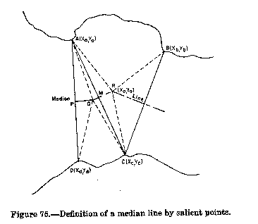
Figure 75. - Definition of a median line by salient points. (See page 167 of the Manual)
The coordinates of a point on the median line exactly midway between two salient points, such as point P, are
Xp = Xa + Xd / 2
and
Yp = Ya + Yd/ 2
Line segment QR represents a portion of the line every point of which is equidistant from salient points A and C, one on each opposite shore. The median line passes through point M midway between salient points A and C, and is perpendicular to line AC.\
Angle points on the median line occur at the intersection of adjacent straight line segments. At an angle point such as point R, the median line is equidistant from three salient points, one of which must be located on the shore opposite the other two.
The coordinates (Xo, Yo) of Point R are determined from the equations
Yo = Hb^2(Xb - Xa) - Haý(Xc-Xa)/ 2 G
and
Xo = Ha^2-2Yo-(yb-ya)/ 2(xb-xa)
in which:
G = (Yc-Ya) (Xb-Xa)-(Yd-Ya) (Xc-Xa)
Ha^2 = Xb^2+Yb^2-Xa^2-Ya^2
Hb^2 = Xc^2+Yc^2-Xa^2-Ya^2
Xa = the X coordinate of point A, and
Yb = the Y coordinate of point B, etc.
If the angle point is equidistant from more than three salient points, any three points can be used in determining the coordinates of the angle point. The three points selected should form the strongest possible geometric figure, that is, most nearly form the vertices of an equilateral triangle.
7-56. Definition Between Meander Lines
When the original meander line defines the true shore, or where new meanders have been run preliminary to the determination of the median line, the points on the median line may be considered as the centers of circles tangent to the meander course on either shore or coincident with one or more angle points of the meander line. The resulting median line is made up of intersecting straight line segments and curved line segments.
Straight line segments represent those portions of the median line every point of which is equidistant from straight line segments of the two meander lines, one on each opposite shore and more or less parallel to one another. Straight line segments also occur under certain conditions when the median line passes between two meander line angle points on opposite shores.
Angle points occur at points of intersection between adjacent straight line segments of the median line. At angle points the median line is equidistant from three or more straight line segments of the two meander lines, one of which segments must be located on the shore opposite the others. Median line angle points usually occur in the vicinity of a meander line angle point when one shore line is concave toward the median line and the opposite shore line is straight.
Curved line segments of the median line occur whenever the median line is equidistant from an angle point on the meander line on one shore and a straight meander course on the opposite shore. The meander line at the angle point is convex toward the median line.
The approximate positions of the angle points on the median line can be determined most easily by graphical means based on aerial photography or maps. A detailed analysis is too lengthy to include here. The surveyor should present the survey data for office computation.
7-57. The partition lines are established in accordance with the same principles for both rivers and lakes. Some variation is necessary in adapting the methods to particular cases. Care must be taken to award each basic holding on the shore the part of the bed in front of it. If one method fails to do this, another method, or a combination of methods, must be used.
7-58. Instructions for surveying the partition lines are found in 50 L.D. 216 (1923), in the syllabus:
In establishing the side boundaries of claims of riparian proprietors to the area between the original meander line on the north and the medial line of Red River in Oklahoma in accordance with the decisions of the Supreme Court in the case of Oklahoma v. Texas, lines should be run from points representing the limits of frontage of the original claims on the meander line to points on the medial line at distances thereon proportionate to the lengths of frontage of the respective abutting owners.
This is an adaptation of the rule outlined in the case of Johnston v. Jones, 66 U.S. 117 (1861). By that rule the new frontage along the water boundary of an accreted area was apportioned in the same ratio as the frontage along the ancient bank. In applying the rule, if the shore has deep indentations or sharp projections, the general shoreline, not the actual length, should be taken in setting the ratio. Normal lines are extended to the median line, above and below the area to be apportioned, at points where the river's course is straight, or nearly so. The intermediate distance along the median line is then prorated according to the frontage. See figure 76(a).
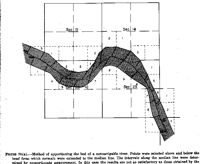
****Figure 76(a). - Method of apportioning the bed of a nonnavigable river. points were selected above and below the bend from which normals were extended to the median line. The intervals along the median line were determined by proportionate measurement. In this case the results are not as satisfactory as those obtained by the method shown in figure 76(b). (See page 169 of the Manual)
7-59. An alternate method is to run each partition line normal to the median line. This method awards to each riparian lot the area immediately in front of it. Where a winding stream course causes the normals to deflect rapidly, more than one normal can sometimes be extended from a single point on the shore, or perhaps no suitable normal can be drawn. A combination of methods may then have to be used to obtain equitable results. For instance, normals might be drawn to the median line at straight parts of the river, and the intermediate parts apportioned along the median lines. (See figure 76(b).
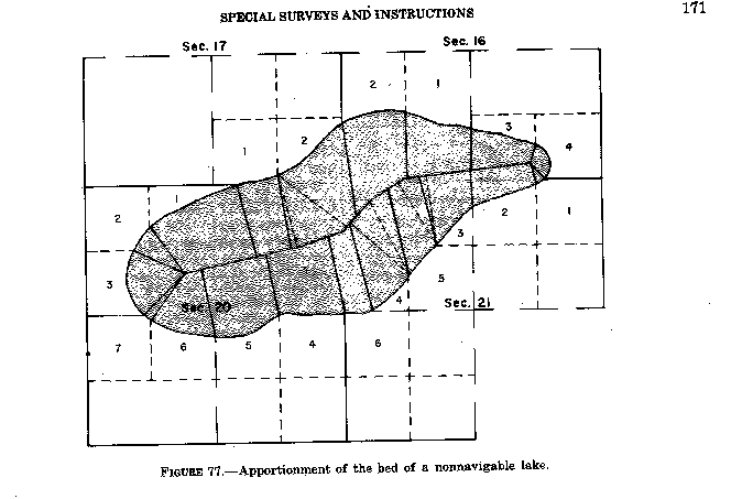
7-60. The method of procedure depends on the shape of the shore line. The courts have generally held that the bed of a round lake should be divided among the riparian owners by ascertaining the center point and connecting that point by straight lines to the boundary corners on the shore. When a lake is long in comparison with the width, the methods applied to streams, with converging lines only at the ends, make the best division.
7-61. In figure 77 the ends of the lake have been treated as arcs of a circle; the remainder of the bed has been divided by use of proportionate measurement along the median line. In this case normals to the median line would have resulted in the encroachment of some lots in front of others, and two normals could have been projected from several points as indicated by the dashed lines.
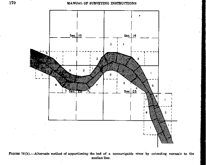
Figure 76(b). - Alternate method of apportioning
the bed of a nonnavigable river by extending normals to the median line.
(See page 170 of the Manual)
 Figure
77. - Apportionment of the bed of a nonnavigable lake. (See page 171 of
the Manual)
Figure
77. - Apportionment of the bed of a nonnavigable lake. (See page 171 of
the Manual)
7-62. The term "accretion" is applied both to the gradual and imperceptible deposition of material along the bank of a body of water and the lands formed by this process.
7-63. "Reliction" is the gradual uncovering of land caused by the recession of a body of water. Relicted land is treated in the same manner as accreted land insofar as its survey is concerned.
7-64. A meander line is not surveyed as a boundary. When the Government conveys title to a fractional lot fronting on a navigable body of water, the intention, in all ordinary cases, is that the lot extends to the water's edge.
7-65. The title and rights of riparian owners in areas below the line of mean high water of navigable bodies of water are governed by State law rather than Federal law. Whether Federal or State law controls the ownership of land accreted to a riparian holding has been answered in a series of cases:
In Borax Consolidated, Ltd. v. Los Angeles, 296 U.S. 10 (1935), the Supreme Court held that "The question as to the extent of this federal grant, that is, as to the limit of the land conveyed, or the boundary between the upland and the tideland, is necessarily a federal question."
The ownership of accretion to land covered by an Indian trust patent was considered in United States v. Washington, 294 F. 2d 830 (1961), cert. den., 367 U.S. 817 (1962). The Ninth Circuit Court of Appeals held that Federal law applied because of the underlying Federal title.
The general question of whether Federal or State law controls as to ownership of accretion was considered in Hughes v. State of Washington, 389 U.S. 290 (1967). The Supreme Court ruled:
The question for decision is whether federal or state law controls the ownership of land, called accretion, gradually deposited by the ocean on adjoining upland property conveyed by the United States prior to statehood. . . .
We hold that this question is governed by federal, not state, law and that under federal law Mrs. Hughes, who traces her title to a federal grant prior to statehood, is the owner of these accretions. . . .
This brings us to the question of what the federal rule is. The State has not attempted to argue that federal law gives it title to these accretions, and it seems clear to us that it could not. A long and unbroken line of decisions of this Court established that the grantee of land bounded by a body of navigable water acquires a right to any natural and gradual accretion formed along the shore. . . .
We therefore hold that petitioner is entitled to the accretion that has been gradually formed along her property by the ocean.
It is therefore settled that wherever it retains title to the original subdivisions along a body of water, either navigable or nonnavigable, the Government may subdivide the lands formed by accretion or by recession of the water, since these, too, are public lands.
7-66. A survey of accreted or relicted land is usually made when one or more of the riparian subdivisions has been disposed of, and it is desired to mark the boundaries of the remaining public land. As in the apportionment of the beds of nonnavigable bodies of water, the riparian owner is entitled to the area lying in front of his basic holdings. In the case of navigable waters the extent of survey is the water's edge. Accrued lands granted by State law to riparian proprietors within the bed of a navigable body of water are not considered here, since their definition would be in accordance with State law.
Apportionment of the accreted lands is usually made by proportioning the new frontage in the same ratio as the frontage along the old shore as outlined in the case of Johnson v. Jones, 66 U.S. 117 (1861), discussed in sections 7-58 and 7-61.
7-67. If there should be substantial areas of accretion to be dealt with that fact will be brought out in the special instructions, with outline of the governing procedure, and the surveying work in reference to all accretion areas will be distinctly mentioned in the field notes and so shown upon the plat.
7-68. Occasionally, subsequent to survey, but before entry, a large body of land has formed by accretion between the meander line and the high water line. If such land had formed after entry, it would merely attach to the riparian holdings. If the land had been in place before the survey and at all subsequent times, it would fall in the class of omitted land, to be treated as hereafter described under that subject. But, in this special case, the meander line is treated as the boundary line of the grants, and patent is construed to convey only the lands within the meander line. Madison v. Basart, 59 I.D. 415 (1947).
7-69. The lands accreted after survey but before entry are not usually surveyed as would be ordinary accreted lands. Instead, the regular rectangular survey is extended to the body of water. The same procedure would be followed in surveying regular accreted lands only if none of the riparian lots had been patented and it was desired to extend the survey.
7-70. In determining what constitutes a "substantial" accretion, to which the rule in Madison v. Basart is applicable, the area of accretion should be compared quantitatively with the riparian lots to which it attached. Some consideration should also be given to the total area accreted. Accretion to a small lot might be large in proportion but negligible in absolute size. From the standpoint of size and relative size, the area in question can be weighed as in the case of omitted lands.
7-71. "Avulsion" is the sudden and rapid change of channel of a boundary stream, or a comparable change in some other body of water forming a boundary, by which an area of land is cut off. An island may result or the avulsed land may become attached to the opposite shore.
7-72. In the case of Nebraska v. Iowa, 143 U.S. 359 (1892), the Supreme Court held:
When grants of land border on running water, and the banks are changed by the gradual process known as accretion, the riparian owner's boundary line still remains the stream; but when the boundary stream suddenly abandons its old bed and seeks a new course by the process known as avulsion, the boundary remains as it was, in the center of the old channel; and this rule applies to a State when a river forms one of its boundary lines.
7-73. An avulsive change cannot be assumed to have occurred without positive evidence. When no such showing can be made, it must be presumed that the changes have been caused by gradual erosion and accretion.
7-74. The change in course of a stream is clearly avulsive when the land between the old and new channels remains substantially as it was. The unaltered condition of the land may be indisputably shown by the continued existence of improvements in place or of timber, undergrowth, and other vegetation. A study of historic documents, especially maps and aerial photographs, will often help in determining what process has taken place. As a general rule the abandoned channel is easily identifiable where an avulsive action has occurred.
7-75. The bed of a new channel resulting from avulsion continues to belong to the owner of the land encroached upon. The bed of the former channel continues to belong to the riparian owners if the stream is nonnavigable. Ownership of the abandoned bed of a navigable stream is governed by State law.
7-76. When the change in a water course is avulsive, and the boundaries remain unchanged, any subsequent movement of the avulsive channel, whether caused by accretion or by another avulsive action, does not change properly lines.
7-77. Lands exposed by changes in water level or accreted subsequent to survey are not erroneously omitted lands. This title is applied to lands, not shown on the plat of the original survey, which were excluded from the survey by some gross discrepancy in the location of a meander line. The unsurveyed land typically lies between the actual bank of a lake, stream, or tidewater and the record meander line.
7-78. In some older surveys temporarily flooded lands, or swamp and overflowed lands, were meandered as if they were permanent bodies of water. In a few cases, meander lines were reported where no body of water ever existed in fact. In still other instances, several lakes have been surveyed as one lake. All are treated in the same manner as those where the discrepancy is a grossly erroneous position of the record meander line. The converse is sometimes found where the record meander line leaves the bank and extends into the body of water. A water area may thus be shown as land.
7-79. Marginal discrepancies between the meander lines and the water at the time of survey fall into two classes, those that are merely technical differences and those that constitute erroneous omission. The guide lines for determining the class of a particular case are laid down in court and departmental decisions.
7-80. If land is to be regarded as erroneously omitted from survey, it must first be shown affirmatively that the area was land in place at the date of the original subdivision of the township. Then, if the land is similar to the surveyed lands, the usual inference that the official survey was correct may be set aside, and the conclusion may be substituted that the land should have been covered by that survey. However, a convincing showing is needed that the representations of the original plat and field notes are grossly in error.
7-81. Applications for the extension of the subdivisional lines to include the areas erroneously omitted from the original survey may be initiated either by settlers on the omitted land or by the owners of the adjoining land. The owner of the surveyed land, or a claimant who has purchased from him, may apply for the survey as a preliminary to quieting the title. There may or may not be adverse claims. The immediate question is the merit of the application under the acts of Congress which grant relief in these cases. A field examination is nearly always required to verify the conditions alleged in the applications. It is objectionable in principle to amend a plat unless large and unwarranted discrepancies can be shown.
7-82. The survey of erroneously omitted lands may also be undertaken as an administrative responsibility for identifying public lands. Such cases may be brought to the attention of the Bureau by a Federal agency having administrative authority over the general area.
7-83. No proof is required to show the whys and wherefores of an erroneous meander line, but only that the line as run and as represented on the plat and in the field notes is in effect grossly in error. The rule is concisely stated in John McClennen, 29 L.D. 514 (1900):
It is not necessary to search for the source of the error. The result is the same whether such error arose from mistake, inadvertence, incompetency or fraud on the part of the men who made the former survey.
7-84. Where lands have been determined to be erroneously omitted from the original survey, the original meander line is made a fixed and limiting boundary segregating the previously surveyed areas from the unsurveyed public lands. The line is reestablished and marked with permanent monuments at the old angle points. Retracement between successive meander corners nearly always will show differences from the record in latitude and departure. The positions of the angle points are adjusted by the broken boundary method described in section 5-43 under "Angle Points of Nonriparian Meander Lines." The angle points are given serial numbers which do not duplicate numbers that may have ben previously assigned in that section. The monuments are marked as shown in section 4-45.
The position of the original meander line having been determined, the survey is extended across the unsurveyed areas. Finally, a new meander line is surveyed in the correct position.
7-85. The requirements for making the plats to represent omitted land surveys are outlined in sections 9-78 through 9-83. The plat should carry a memorandum precisely stating the situation with reference to the survey represented, as in the following cases:
The position of the original record-meander courses of the so-called Moon Lake is shown by an irregular line with numbered angle points. This line as thur originally reported was grossly in error, and has therefore been marked as a fixed boundary, with the directions and lengths of the several courses adjusted to the record of the original survey.
The position of the original record-meander courses of Ferry Lake fronting along lot 4, section 9, and lots 2, 3, and 4, section 10, is shown by an irregular line with numbered angle points. This line as thus originally reported was grossly in error, and has therefore been marked as a fixed boundary, with the directions and lengths of the several courses adjusted to the record of the original survey.
The position of the original record-meander courses of a lake reported as having been located in section 36 is shown by an irregular line with numbered angle points. This line as thus originally reported was grossly in error, and with the exception of certain courses fronting along lots 1, 2, and 9, has therefore been marked as a fixed boundary, with the directions and lengths of the several courses adjusted to the record of the original survey.
This memorandum is in addition to the memorandum referring to the dependent resurvey of the original section lines.
7-86. The three examples represented by the memoranda in section 7-85 are situations where the survey of erroneously omitted areas has been necessary. An examination of the manner in which each type was treated will help in determining how to approach similar cases.
7-87. Nonexistent Moon Lake: The plat of T. 12 N., R. 9 E., Fifth Principal Meridian, Arkansas, approved October 27, 1845, shows a meandered lake occupying the greater part of sections 22 and 27 and extending a short distance into section 26. The field notes of the line between sections 26 and 27 call for an intersection with the southeast side of "Sunk Lake," here classed as impassable and navigable. The surrounding fractional subdivisions as surveyed were all patented to the State under the provisions of the swamp land grant.
The case originated on the report of the removal of timber from portions of the area under the color of title arising through the ownership of the adjoining land. The report indicated that practically all of the area was high, dry land, covered with a growth of large timber, with no difference in the character of the land from that which had been included in the original subdivision. The topography, elevation, and timber all revealed little if any change since the date of the subdivision of the township.
The greater part of the excluded area was found to be covered with various species of oak, maple, cottonwood, hickory, sycamore, hackberry, cypress, and willow. Many of the trees were of great age, 300 years or more, and many of them indicated strictly upland site conditions. The area was found to be level land, at about the same elevation and in some places higher than the surrounding lands, though there was evidence of what had been a slough along parts of the edge of the so-called lake.
7-88. By decision dated November 30, 1909, bearing departmental approval, the Commissioner of the General Land Office held that the area, 853.25 acres, was not a navigable lake on June 15, 1836, the date when Arkansas was admitted into the Union, nor in 1841, at the date of the subdivision of the township. As the land was in place at that period and was not permanently covered by water, it was part of the public domain, and title had not passed from the Government.
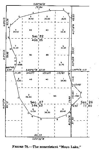
Figure 78. - The nonexistent "Moon Lake." (See page 174 of the Manual)
On November 5, 1917, the Supreme Court announced an opinion (Lee Wilson & Company v. United States, 245 U.S. 24) denying the merits of the riparian claims to the area within the meander line of the so-called lake, restating two legal propositions held indisputable because settled by previous decisions:
First. Where, in a survey of the public domain a body of water or lake is found to exist and is meandered, the result of such meander is to exclude the area from the survey and to cause it as thus separated to become subject to the riparian rights of the respective owners abutting on the meander line in accordance with the laws of the several States. Hardin v. Jordan, 140 U.S. 371 (1891); Kean v. Calumet Canal Co., 190 U.S. 452 (1903); Hardin v. Shedd, 190 U.S. 508 (1903).
Second. But where upon the assumption of the existence of a body of water or lake a meander line is through fraud or error mistakenly run because there is no such body of water, riparian rights do not attach because in the nature of things the condition upon which they depend does not exist and upon the discovery of the mistake it is within the power of the Land Department of the United States to deal with the area which was excluded from the survey, to cause it to be surveyed and to lawfully dispose of it. Niles v. Cedar Point Club, 175 U.S. 300 (1899); French-Glenn Live Stock Co. v. Springer, 185 U.S. 47 (1902); Security Land & Exploration Co. v. Burns, 193 U.S. 167 (1904); Chapman & Dewey Lumber Co. v. St. Francis Levee District, 232 U.S. 186 (1914).
Other important points in this and similar cases are found summarized in the syllabus:
If in the making of a survey of public lands, an area is through fraud or mistake meandered as a body of water or lake where no such body of water exists, riparian rights do not accrue to the surrounding lands, and the Land Department, upon discovering the error, has power to deal with the meandered area, to cause it to be surveyed, and lawfully to dispose of it.
The fact that its administrative officers, before discovery of the error, have treated such a meandered tract as subjected to the riparian rights of abutting owners, under the State laws, and consequently as not subject to disposal under the laws of the United States, cannot stop the United States from asserting its title in a controversy with an abutting owner; and even as against such an owner, who acquired his property before the mistake was discovered and in reliance upon such actions and representations of Federal officers carrying assurance that such riparian rights existed, the United States may equitably correct the mistake and protect its title to the meandered land. The equities of the abutting owner, if any, in such circumstances are not cognizable judicially, but should be addressed to the legislative department of the Government.
The swamp land act of September 28, 1850 (ch. 84, 9 Stat. 519), did not convey land of its own force, without survey, selection, or patent.
7-89. The surveying in the Moon Lake case consisted of a retracement of the boundaries of the several sections, a restoration of the obliterated corners, a remonumentation of all of the corners, a retracement of the record meander line with monumentation of the angle points, and a completion of the fractional section lines.
7-90. Erroneously meandered Ferry Lake: Ferry Lake is one of the lakes formed by the "Great Raft" of the Red River. The "Great Raft" was a complex series of logjams which probably began to form in the fifteenth century. Over a long period of time the raft moved upstream as the lower end decayed and additional material lodged against the upper end. As the raft moved, it blocked off tributaries and forced the main river into new channels. Numerous lakes and bayous were formed which extended almost to the Arkansas-Louisiana State line. Ferry Lake was formed near the close of the eighteenth century. It was a permanent, navigable body of water in 1812 when Louisiana was admitted into the Union. Because the "Great Raft" was a hindrance to navigation and transportation, Congress provided funds by the Act of May 23, 1928, to remove it. Clearing the river was a slow process, and the removal of the "Great Raft" was not completed until 1873. Most of the lakes were thereby artificially lowered or drained, and the State retained the uncovered portions of the beds. Only lands above the line of mean high water before the artificial reliction could be considered in determining if there had been an erroneous omission from the original survey. Location of the mean high water line was one of the complications of the case.
The plat of T. 20 N., R. 16 W., Louisiana Meridian, Louisiana, approved August 31, 1839, shows the north boundary of the township discontinued on the bank of Ferry Lake (now Caddo Lake). The line between sections 10 and 22, in harmony with the remaining subdivisions, was discontinued on the lake bank, but the line between sections 3 and 10, instead of being extended to the main lake front was stopped on an arm or bay of the lake. The meander line through section 3 could be and was run with reasonable conformity, but in section 10, owing to the failure to extend the northern section boundary to the main lake front, there was no possibility of running a true meander line. Excepting the end courses, the record line, as developed, bears no proper relation to the bank as it existed at the time of the survey.
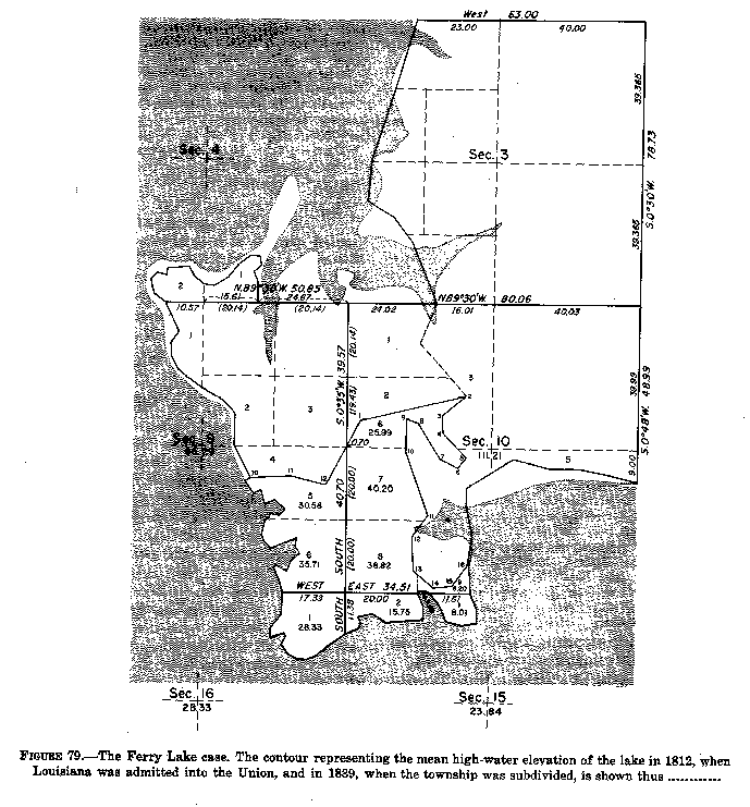
Figure 79. - The Ferry Lake case. The contour
representing the mean high-water elevation of the lake in 1812,
when Louisiana was admitted into the Union, and in 1839,
when the township was subdivided, is shown thus ............. (See page
176 of the Manual)
The plat of fractional sections 4, 9, and 10 of the same township, approved August 18, 1871, represents an extension of the lines between sections 3 and 10, and between sections 4 and 9, to the main lake front. The corner of sections 3, 4, 9, and 10 was established in this survey, also a meander corner on the west side of a narrow bayou which drains out of the north part of section 9; but again, for no apparent reason, in running south ont he line between sections 9 and 10 the survey was terminated at a point more than 3,400 feet north of the bank of Ferry Lake. A part of the meander courses in sections 4 and 9 were actually run, but the remaining courses, particularly those which connected with the terminal point on the line between sections 9 and 10, were merely a traverse line through the woods, though represented in the field notes and shown on the plat to be the bank of the lake.
Following the discovery of oil and gas, mineral applications were filed with the Department in 1909 and 1910. The locations covered not only the omitted area but the bed of the lake. It was alleged that large errors had been made in running the meander lines, that the lake was merely a temporary body of water, and that it had not been navigable in 1812 when Louisiana was admitted to the Union. By 1910 all of the fractional lots adjoining the omitted area had been disposed of by the United States.
The report of the field investigation covered the historical data, the geology of the lake basin, an examination of the forest trees, and the surveying situation. It was concluded that Ferry Lake existed as a navigable body of water in 1812, though there had been a marked recession of the lake by 1910; and that in neither of the surveys of 1839 and 1871 had the lake been correctly meandered in sections 9 and 10, either as it was at the dates of the surveys or as it was in 1812.
The soil, topography, and timber on the omitted area were the same as found on the surveyed land. Along most of the meander line there was no indication of there ever having been a lake bank or water-washed escarpment of any kind.
The forest growth on the omitted land included overcup oak, sweet gum, and red gum on the lower levels, and on the higher levels post oak, blackjack oak, Spanish oak, hickory, pine, and other varieties, many of them of great age, and clearly the descendants of a mixed forest that had existed for many centuries. The overcup oak was found in a belt immediately above a belt covered predominately by cypress, which occupied the plain terraces above and below an easily traceable escarpment. This bank, which had been made by the waters of Ferry Lake, continued without interruption around the entire basin. A contour survey showed the elevations in the omitted area in sections 9 and 10 to range up to 17 feet above the former lake level. The area omitted in these sections amounted to 229.67 acres.
7-91. Upon a review of the record, the Attorney General of the United States, in a letter to the Secretary of the Interior, dated September 11, 1916, concluded:
That no action should be taken to enforce or assert any claim by the Government to that portion of the area involved which is covered by the waters of the lake because if the State's title by virtue of its sovereignty should fail for any reason, I see no way of successfully resisting her claim under the swamp land grant.
However, in so far as concerns the land lying between the old meander line and the waters of the lake, I entirely agree with you that it constitutes unsurveyed public land of the United States, and . . .
On January 2, 1923, the Supreme Court of the United States announced an opinion (Jeems Bayou Fishing & Hunting Club v. United States, 260 U.S. 561), denying the claims to the land in sections 9, 10, 15 and 16, adverse to those of the Government, and commented:
The inaccuracy of the plat is plainly apparent upon a like inspection. Why ------ made the survey and returned the plat as he did is a matter of speculation, but the facts demonstrate that no survey of the large, compact body of land, which includes the tract in controversy, was ever made. The circumstances, as well as the extent and character of the lands, necessitate the conclusion that the omission was of deliberate purpose or the result of such gross and palpable error as to constitute in effect a fraud upon the Government.
7-92. Surveying the Ferry Lake case consisted of the steps mentioned in the Moon Lake case, also a monumentation of the contour which agreed with the evident mean high-water elevation of the lake as it was in the year 1812.
7-93. Crooked Lake and Bear Lake: The plat of T. 43 N., R. 6 E., Fourth Principal Meridian, Wisconsin, approved April 6, 1863, shows a meandered lake in section 36. Meander corners were established regularly on the south and east boundaries of the section. The field notes show the running of meander courses through the section on opposite sides of the lake, and call for high banks, along timbered land. No mention is made of an arm of a lake extending northwesterly into section 25. The fractional lottings were disposed of according to the representations of the plat.
By letter dated April 16, 1923, the Commissioner of the General Land Office advised the Secretary of the Interior of an application to make a forest lieu selection for the NE¬SW¬ sec. 36 (lot 15, figure 80), which according to the representations of the township plat would be located entirely within the bed of the meandered lake as above described. This letter contains a review of the facts as developed by a field examination, and concludes with a recommendation that the land theretofore shown as a meandered lake be surveyed and a proper plat constructed. The proposed action bears departmental approval.
The report of the field examination showed the following facts:
The south and east boundaries of the section cross two lakes instead of one, the lakes being separated by a body of land amounting to 236.90 acres contained within the lines represented on the original plat as the banks of the one meandered lake. This area is rolling upland ranging up to 50 feet above the level of either lake, and forested with pine, hemlock, birch, maple and spruce timber. There was no evidence of any changes in the water level of the lakes, nor of any escarpment along the fictitious meander courses connecting them, these lines having been found to traverse rolling land instead of following a contour, with not the slightest difference between the character of the land, soil or timber on the area theretofore surveyed and that which had been omitted. The shores of the two lakes were well defined, with banks from 3 to 8 feet high, bordered by a strip of level land from 10 to 30 feet in width, surrounded by rolling hills. The geologic formation, as well as the forest trees, indicated great age.
The surveying work to be done consisted of the steps previously outlined in the Moon Lake case.
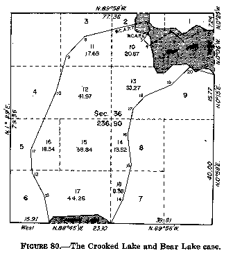
Figure 80. - The Crooked Lake and Bear Lake case. (See page 178 of the Manual)
7-94. Lands omitted from the original survey lying between the position for the record meander line and the actual bank of a lake, stream, or tidewater, situated in front of Government-owner subdivisions, are subject to survey as public land although they may not be of sufficient size and extent to constitute gross error fraud in the original surveys.
If title to all the subdivisions in a section, shown to be riparian by the plat of the original survey, is still int he Government, and there is no reason for retaining the original lottings, new areas and designations may be returned for the public land. This procedure ordinarily is not involved unless warranted by the values involved or justified by the difference in area of the subdivisions. However, when title to some of the record riparian subdivisions has passed into private ownership and no claim can be maintained by the United States to the omitted land in front of these subdivisions, partition lines are run and monumented segregating the public land from the area belonging to the private owners. Generally it is necessary to subdivide the sections in the regular manner, reestablish the original meander line, and remeander the body of water. Lot numbers and areas are shown on the official plat for the public land being surveyed for the first time.
Where title to all the land in a section based upon the plat of the original survey has passed from the Government, it is not necessary to reestablish the original meander line. This line is protracted upon the survey plat, which should be prepared in the manner similar to the method adopted for showing an area formed by accretion in front of patented lands (figure 88, chapter IX). The division lines between patented holdings are not surveyed in the field or shown by protraction upon the plat.
The partition lines between the Government land and privately owned land are run in the same manner as partition lines dividing areas formed by accretion. The general rule is to follow the method described in Johnston v. Jones, 66 U.S. 117 (1861), that is, to apportion the new frontage along the water boundary in the same ratio as that along the line of the record meander course. There are acceptable variations to this rule where local conditions prevail and the added lands are not of great width or extent. In such cases the extension of normal lines to the water boundary is an equitable division to the avoidance of unrealistic or oblique lines which are not commensurate with the considered manner of the land's formation.
7-95. The acts of Congress which granted to certain States the swamp and overflowed lands within their respective boundaries were listed in chapter I. These lands are not conveyed without survey, selection, or patent. Lee Wilson & Company v. United States, 245 U.S. 24 (1923). They are surveyed as public lands and subject to classification at that time.
In San Francisco Savings Union, et al v. Irwin, 28 Fed. 708 (1886), aff. Irwin v. San Francisco Savings Union, et al., 136 U.S. 578 (1890), the court stated:
The act of 1850 grants swamp and overflowed lands. Swamp lands, as distinguished from overflowed lands, may be considered such as require drainage to fit them for cultivation. Overflowed lands are those which are subject to such periodical or frequent overflows as to require levees or embankments to keep out the water, and render them suitable for cultivation.
Swamp lands include marshes and intermittent ponds which do not have effective natural drainage, particularly where such conditions are long continued.
Overflowed lands include essentially the lower levels within a stream flood plain as distinguished from the higher levels, according to the characteristic effect of submergence where long continued.
7-96. Tidelands are coastal areas situated above mean low tide and below mean high tide, particularly as they are alternately uncovered and covered by the ebb and flow of the daily tides. As a part of the bed of navigable waters, such lands belong to the States. Pollard's Lessee v. Hagan, 44 U.S. 212 (1844). Tidelands are mentioned here to stress their distinction from swamp and overflowed lands. Coastal "salt marshes" that are covered by the daily tide are tidelands and not subject to survey. On the other hand, coastal marshes that are not covered by the daily tide are swamp and overflowed lands within the meaning of the grants and are subject to survey.
7-97. It has already been emphasized in section 3-115 that meander lines will not be established between the upland and the swamp and overflowed lands. Riparian rights, which are applicable within the beds of lakes, streams, and tidal waters, are not enforceable over the swamp and overflowed lands granted to the States. The survey of meander lines at the margin of swamps in the past has been in important cause of the erroneous omission of lands from survey.
7-98. The following rules should be followed in making surveys or field examinations of swamp and overflowed lands:
(1) According to R.S. 2481 (43 U.S.C. 984), any legal subdivision the greater part of which is "wet and unfit for cultivation," shall be included in the category of swamp and overflowed lands. When the greater part of a subdivision is not of that character, the whole of it shall be excluded. The legal subdivision referred to is the quarter-quarter section or comparable lot.
(2) "Wet and unfit for cultivation" is interpreted to mean that the land must have been so swampy or subject to overflow during the planting, growing, or harvesting season, in the majority of years at or near the date of the grant, as to be unfit for cultivation in any staple crop of the region in which it is located, without the use of some artificial means of reclamation such as levee protection or drainage ditches.
(3) A subdivision which becomes swampy or overflowed at a season of the year when this condition does not interfere with the planting, cultivating, or harvesting of a crop at the proper time and by the ordinary methods is not "made unfit for cultivation" and does not qualify under the swamp land grant.
(4) Tame grass or hay, when produced by the ordinary methods of preparing the ground, is considered a staple crop, as well as the cereals, or cotton, or tobacco.
(5) In the administration of the swamp acts the States have been allowed optional methods of preparing the lists of subdivisions that are to be identified as swamp and overflowed within the meaning of the acts. But the surveyor must determine with accuracy the position and extent of the swamp and overflowed land within the area under survey regardless of the methods employed by the States in asserting claims.
(6) Alabama, Indiana, Louisiana, Michigan, Minnesota (excepting as to lands within the Indian reservations), Mississippi, Ohio, and Wisconsin have elected to base their swampland lists on the field note record. In these States it is imperative that the field notes include a specific list of the subdivisions each of which is more than 50 per cent wet and unfit for cultivation, regarding such character as at the date of the passage of the granting act.
Arkansas, by the Act of April 29, 1898 (30 Stat. 367; 43 U.S.C. 991), relinquished all right, title, and interest to the remaining unappropriated swamp and overflowed lands within its boundaries.
(7) In California, under R.S. 2488 (43 U.S.C. 987), the swampland lists are based upon the representations of the plat of survey, and in this State it is imperative that the plats correctly show the conditions in this respect.
(8) The selection of swamp lands in Florida, Illinois, iowa, Missouri, and Oregon, and in Indian reservations within Minnesota, is based upon investigations and reports by representatives of the State and of the Bureau of Land Management, but this does not set aside the Manual requirements for the usual complete showing of the character of the land.
7-99. It is always important to note any marked changes in the water level and drainage conditions of the region, and to ascertain the situation as of the date of the granting act. It is desirable to secure the testimony of persons who have known the lands for long periods. The most convincing evidence of the land's character at the date of the granting act is the older native timber, as the varieties reflect their site conditions with great certainty.
This line of investigation requires an inquiry into the habitat of the forest species which are found, particularly as to whether the usual range of the tree is within low wet ground, as for example the cypress, tupelo, sweet gum, water ash, water locust, and red bay of the southern latitudes, and the tamarack, white cedar, black spruce, swamp spruce, and black ash of the northern latitudes of the United States. The presence of any of the species named indicates the possibility of swamp land, and while conclusive with some of them, others of the species named have a wider range and may be found associated with upland varieties. If upland varieties are present the plain inference will be that the site conditions are that of upland, even though a forest species may favor moist rich soil.
7-100. Earlier manuals have stressed the appraisal of soil characteristics as an essential part of the survey returns. This classification has been an invaluable aid in the development of the public domain, both to the prospective settler and in the administration of natural resources. Such information is now generally available from other sources, and its provision by the field notes is not as important as it once was. Yet, in the making of original surveys, it is necessary to tie the available information to specifically described lands. Further, the general law (R.S. 2394; 43 U.S.C. 751) requires the surveyor to note and report upon the soil types. These requirements will hereafter be limited to lands being surveyed for the first time and need not be routinely applied to resurveys unless provided for by the special instructions.
7-101. The soil types, when considered in relation to precipitation and other climatic factors, the drainage, the adaptability of the terrain to irrigation, the elevation, and the latitude, will indicate whether the highest and best use of the land is for farming, grazing, forestry, or other purposes.
7-102. An outline of the matters to be considered in soil studies is presented below as a guide to the surveyor in making his report.
(1) Texture: Gravel, coarse and fine; sand, coarse and fine; sandy loam; silt loam; loam; clay, heavy and light; and much.
(2) Structure: Single grained, pulverulent, and lumpy.
(3) Color: Surface soil and subsoil, both when dry and when wet.
(4) Chemical properties: Acidity, alkalinity, and humus content.
(5) Depth: Surface soil and subsoil.
(6) Location: River bottom or flood plain, bench, slope, plateau, prairie, and mountain.
(7) Topography: Level, rolling, broken, hilly and mountainous; and elevation above sea level.
(8) Drainage: Direction, depth to water table, and quality, as poor, good, or erosive.
(9) Mode of formation: Water laid, glacier laid, wind laid, and residual.
(10) Geological derivation:
(a) Sedimentary rocks are either formed of fragments of other rock transported from their sources and deposited as conglomerate, sandstone, and shale; or formed by simple precipitation from solution, as limestone, or of secretions of organisms, as some coastal rocks.
(b) Metamorphic rocks: Formed through change in constitution, especially those due to great pressure, heat, and water, and resulting in a more compact of more highly crystalline condition, including, for example, quartzite, marble, slate, and schist.
(c) Igneous rocks: Formed through the action of intense heat, including, for example (first, eruptive rocks) basalt, lava, and volcanic ash; (second, trap rock) felsite and quart-porphyry; and (third, granular rock) granite, diorite, and porphyry.
7-103. Soil has its origin in the material which comes from the disintegration of the rocks. Roots and other vegetable matter in the soil are by decay gradually converted into humus, which is found only in the surface soil, and in quantities which vary with the activity and profusion of plant life. Plant food comes from the chemical elements contained in the rock and the humus; one is the product of inorganic matter, the other a product of the decomposition of organic matter. Plants draw four elements from the soil that are essential to their development; phosphorus, potassium, nitrogen, and calcium. Other elements are usually present in plentiful supply and so are of less importance. The amount of humus is important to the fertility of the soil, and it absorbs and retains moisture.
Soil bacteria thrive best in soil that is rich in decaying vegetation, with favorable proportions of line, air, light, warmth, and moisture, and through their presence much nitrogen is taken from the air for storage in the ground. The relation of these things leads to the notable observation that soils seem to select their plants, or vice versa. There is found in a certain soil type one class of grasses or forest cover, in another soil very different plant life. These are the keys to a study of the soil, and when all are considered in connection with the moisture, climatic, and other conditions of the environment, will very largely determine its value for agriculture, stock grazing, or forestry.
7-104. The following is an illustration of a general description of the land and soil types found within a selected township, designed to bring out rather minute references to the soil structure:
Land, level, and gently rolling plateau, with elevation from 500 to 700 feet above sea level. Soil, fine sandy loam; surface soil dark gray to black, rich in humus, from 10 to 15 inches deep; subsoil, light brown loam, 36 inches deep, resting on gravel bed; sedimentary origin, lake laid. Drainage good, the stream system being the __________ River and its tributaries. The normal precipitation of the region is ordinarily deficient for general farming, but the soil is well adapted to any of the cereals usually grown in this latitude by dry-farming methods, and it produces excellent grasses, both native and tame.