The basic assertion of the article is still that the hour angle provide better results than typical altitude observation, if proper precautions are taken, but that the altitude observation can still be useful thing to know how to do, and can be a good check on the hour angle. In addition, under normal conditions, levelling error is a significant concern which may limit the overall accuracy of any observation - jlw
Jerry L. Wahl
Branch of Cadastral Surveys
Bureau of Land Management
California State Office
2800 Cottage Way, E-2841
Sacramento, California 95825
Over the decade the popularity of using solar observations in surveying has soared, mostly spurred on by numerous articles and publications by vigorous proponents of the hour angle method. This paper is a brief discussion and comparison of the two methods, altitude versus hour angle, including a discussion of the effects of the most frequent field blunders as well as the inherent errors found in each method. One source of uncertainty in the altitude method is the proper determination of atmospheric refraction. A major problem with both types is levelling error. While somewhat subject to personal opinion, the proposition is argued that the altitude method should not be relegated to the technological scrap heap.
My experience includes about 8 years in the field as an employee of the Bureau of Land Management, Cadastral Survey, throughout the United States. Almost all BLM Cadastral Surveys are controlled by astronomic azimuth. As a result I have had the opportunity to gain considerable experience with astronomic azimuth observations of many types in actual field conditions, taking 1 or 2 astronomic observations per work day under differing meteorological and geographic conditions. As a result of this experience I have some thoughts on the pros and cons of various methods.
In the last 6 or 7 years the use of astronomical observations in surveying has seen a great come back. Once a common tool in land surveying, the growth of urban surveying over the years since the 1940's seemed to have caused a decline in the use of astronomy for azimuth determinations. In 1984, POB Magazine published an article entitled `Advantages of the Hour Angle Method for Sun Observations' by David R. Knowles. This article stirred some good feedback and debate, and has been followed up by numerous informative technical addendum. At about the same time, R. B. Buckner published his book titled A Manual on Astronomic and Grid Azimuth'. I believe that these publications and others helped revive interest and excitement about surveying astronomy. These publications provided surveyors with a thorough background, as well as instructions and techniques to determine accurate astronomic azimuth. They were also strong proponents of the hour angle method for solar observations. A side effect of some of these articles was the denigration of the value and accuracy of the traditional solar altitude method for azimuth. What I am trying to present here is a more moderate view and a defense of a place in your skills tool kit of the altitude method.
So what are the two methods and what are the pros and cons? Briefly:
Hour Angle Method
The hour angle method requires:
the following are then computed:
The advantages of the hour angle method include the fact that there is no need to observe the zenith angle to the Sun. This results in simpler pointings as compared to the altitude method. It also allows a successful observation under some conditions where the solution to an altitude observation is highly unstable. The disadvantage is that it requires extraordinary care in the time determination, such as: using time signals, having an accurate watch, applying proper correction to UT1, developing good technique in reaction time with watch. Also, some extra work is required to determine adequate longitude.
Altitude Method
The altitude method requires:
The following values are then computed:
The advantages of the altitude method include a minimal need for accurate time or determination of longitude. The disadvantages are that it requires a more complex pointing procedure to obtain both the horizontal and zenith readings to the Sun, and it requires some determination of atmospheric conditions in order to figure the refraction correction. In addition the refraction determination is to some degree an educated guess.
Primary Difference. The primary difference between the methods comes down to the fact that the hour angle requires extraordinary care in determination of time, whereas the altitude requires extra care and skill in determination of the altitude.
Time. As noted above, the hour angle method is critical for time. It was a much less practical method prior to the ready availability of accurate electronic time pieces around 1978. Before that time it was still possible to perform a reasonable hour angle observation, but great care was required. The accurate digital watch was a great help. The introduction of the HP41C time module was another significant aid in bringing accurate time to the field. The technical evolution of field computations combined with accurate time keeping have tilted the scale towards the hour angle method. Prior to 1978 the altitude method could be said to have had the edge in terms of overall ease of observation and practicality.
Vertical Angle. The primary criticism of the altitude method is the difficulty of obtaining a simultaneous vertical and horizontal sun pointing. This is bound to also degrade the accuracy of both angles. Another relevant factor in the final altitude used in the computation is the proper determination of atmospheric refraction. Based on my own experience the ability to point on vertical limbs of the Sun or obtain a zenith measurement with a Roeloffs prism has been underestimated by many. It is true that some skill is involved, but skill in measurement IS a legitimate attribute for a surveyor to pursue.
It should also be noted that texts discussing accuracies of altitude observations prior to 1980, such as the K & E text, frequently underestimated the accuracy of the altitude method. I surmise that this may have been based upon results from work with the transit. In this day of theodolites we need to remember that it wasn't so long ago that the 20 or 30 minute transit was the primary instrument of land surveying. By repetitions the transit can easily achieve accuracies of better than 10 seconds on horizontal, but there was no similar refinement available for vertical angle measurement. Some advantage can be derived from straight statistical averaging, but that advantage could easily be overcome by misadjustment of the vertical circle as there was no automatic vertical compensation.
The use of the theodolite, particularly the 1 second direction instrument has generally allowed a reliable determination of the vertical angle of commensurate accuracy with the horizontal. It is my belief that it is possible to achieve an averaged zenith pointing to the Sun over 6 readings within the 5 to 10 second range.
The observed vertical or zenith angle to the Sun must be corrected for atmospheric refraction as well as parallax. The parallax correction is a small offset and easily and accurately computed. The determination of refraction is somewhat more uncertain. The refraction correction represents the amount of bending in the vertical as light from the Sun enters and passes through the varying density of air in the earth's atmosphere. This bending results in the Sun's image appearing at a different and higher vertical angle than it's true direction. This bending increases as the Sun appears nearer to the horizon since the light rays are passing through more atmosphere and at a more oblique angle.
References on geodetic astronomy indicate that the formula and tables used to determine the refraction correction may be accurate to around 3 seconds for vertical angles of 15 degrees or greater. The accuracy estimates given in that context should be considered with some skepticism considering that geodetic astronomy is primarily performed at night where atmospheric conditions affecting refraction would normally be more stable. A good opportunity for further research would be an analysis of actual daylight refraction values under varying conditions. Research into the historical work on refraction, much of it performed in the last century might also shed more light on the absolute reliability of atmospheric refraction determination by classical means.
The refraction correction can be determined from tables or from numerous formula offering various degrees of simplicity and accuracy. There are easily 20 different formula available from different authors. The refraction models used to derive most formula assume an ideal atmosphere with density (and index of refraction) varying as some function of elevation, and manipulated to fit actual refraction data.
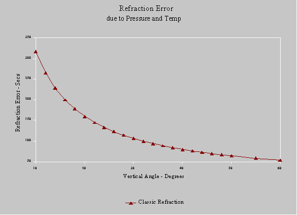
Figure 1
Figure 1 shows an example of the refraction correction as a function of vertical angle. The refraction also varies with atmospheric pressure and temperature since these affect the air density and thus the refractive index of the atmosphere. Variation due to inaccurate measurement of pressure and temperature are shown in Figure 2. It is necessary to observe or at least guess the air temperature and absolute pressure. Many observers use a factor based upon observers elevation, since pressure variation due to elevation is the dominant systematic effect over the variations due to meteorological conditions.
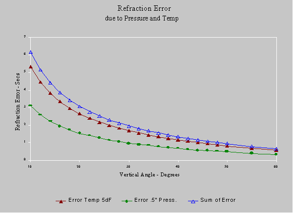
Figure 2
Typical Observation Errors
Figure 3 shows the error in final azimuth for the two methods for the situation where declination is 15 degrees. This represents the minimum error in magnitude for the summer months. In this case the time error for the hour angle method is assumed to be 0.5 second, what I consider achievable under average field conditions. A good degree of care is still required to achieve this value. The altitude error curve is a result of the combination of an 8 second zenith pointing error, and refraction estimate errors resulting from uncertainty in pressure of 1/2 in. and 5 degrees F. These are also fairly reasonable figures for normal care in observation.
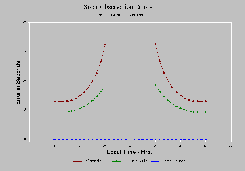
Figure 3
The range of usable vertical angles is from 10 degrees to around 50 to 55 degrees. Lower angles are frequently obscured by terrain features and although you may think you can sight high using an eyepiece prism, you will be lucky to get usable results with the rapid increase in the effect of leveling error.
Error due to mislevel of the instrument is common to both methods. It has been my experience that this is a highly underrated source of error. It is very difficult to maintain an instrument in level while in direct sunlight, even more difficult to rely upon the plate bubble which is easily warped by uneven heating. Working over many years in the field leads me to believe that it is optimistic to assume you can level much better than half a bubble graduation (usually 20 or 30 seconds per graduation.)
The errors introduced from mislevel increase dramatically for steep vertical angles. This is one reason why great care in leveling does not usually become a factor in terrestrial angle measurement, but is highly critical at steep verticals. The effect is not strongly considered by Buckner, or originally by Elgin and Knowles. In a 1987 article Elgin and Knowles cite a value of 4 seconds azimuth error resulting from a 10 second levelling error. That figure was for a fixed condition. Tables 4 thru 8 illustrate the level error for different conditions, as well as the effect on the observation error for the altitude and hour angle methods.
Correction by reading the level vial is impractical as the level vials calibration is constantly changing as affected by solar radiation heating unless the level is kept well shaded. A striding level would also be fairly useless since any open spirit level will be affected solar heating. Good luck is more likely with instruments that compensate internally for vertical error, such as the now antique HP3820. Levelling by use of the internal vertical compensator may also prove advantageous. It is difficult for an instrument operator to maintain level throughout an observation. Figure 4 illustrates the resultant errors in the observation methods for the same conditions as Figure 3 but with the addition of the results of a 10 second leveling error at right angles to line of sight.
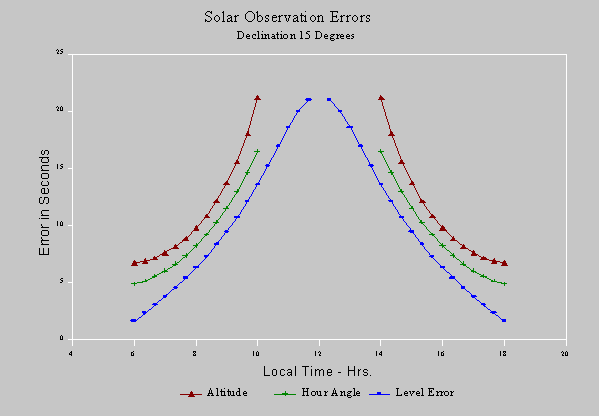
Figure 4
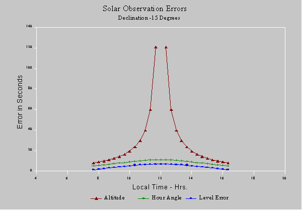
Figure 5
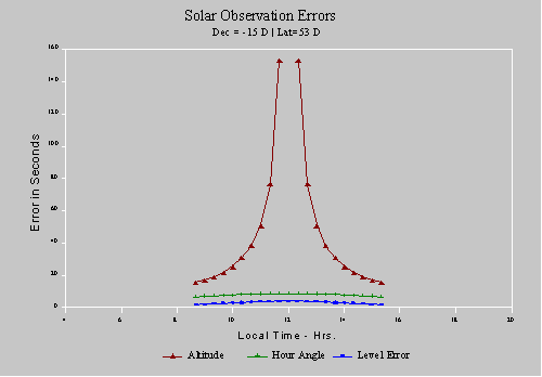
Figure 6
It is clear from this analysis that the hour angle method has a more dominant advantage in the winter months, as shown in Figures 5 and 6. Higher latitudes, such as in Alaska cause a similar shift to the advantage of the hour angle method, but what we have NOT discussed here is one fatal flaw in the hour angle method, it is incredibly vulnerable to blunders in time.
The revenge of the altitude solar is that the promise of greater accuracy can end in large errors due to an unseen blunder. I have noted several stories of surveyors who have been caught with blunders resulting from such things as setting of a time module from time signals to the fraction of a second, but failing to notice that the minutes are off 1, 2, 5 or 10 minutes. This will produce very consistent internal computed results with no indication of the error. Users of the hour angle method should use some method to detect such blunders, such as to check and read the time before and after the observation or field day. Another problem can result if your HP41 program does not record or display the time used for the computation but merely cranks out an azimuth. Later discovery of a time error will not allow a recomputation.
This type of blunder has also happened to me and to several of my colleagues, but was quickly caught and corrected. This is because we used the altitude as an essential check against major blunders which can and do slip into the `easier' hour angle method. A solar can be made self checking if at least one pair of zenith measurements is incorporated into any hour angle observation and reduced using the altitude method. This contrasts the statement taken out of context from Buckner, page 54, 4-4
`The surveyor should not measure the vertical angle to the sun. There is no need for it' . . . `Some may want to check the hour angle results using the altitude formula by doing this, but to check a superior method using one that is inferior, and losing the precision of the superior method in the mechanical process of attempting to do so does not make sense.'
In summary the altitude method is not so inaccurate as many have indicated, although with care an hour angle will normally produce better results, errors due to levelling and high vertical angles in summer months decrease the gap. In addition a surveyor who avails himself of more than one tool for azimuth determination has an advantage on those occasions where precise time, longitude, and the need for astronomic azimuth of reasonable accuracy do not co-exist. The hour angle method has proven on many occasions to lead observers into overconfidence where a simple blunder can sneak into the observation unchecked resulting in errors of 15 minutes or more. The altitude method provides a strong check to a good hour angle observation due to its lack of criticality for time and longitude.
![]()